


Reporter 84
Reporter 84 explores what it takes to make smart ecosystems leading to smart digital realities for a true digital transformation.


Explore our wide selection of on-demand webinars and register for upcoming webinars in our Laser Scanning Webinar Hub.


Reporter 84
President’s Message
In our business, we talk a lot about connecting. Field work is connected back to the office through sophisticated software. Machines on a construction site are connected to each other through integrated platforms. People are connected to one another through technology. This connection is what distinguishes modest ecosystems from smart ecosystems, the basis for smart digital realities. In this edition of Reporter, we define what it takes to make smart ecosystems leading to smart digital realities for a true digital transformation.
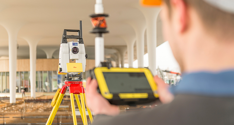
The construction industry is rapidly digitalising and connecting more and more the field to the office. When Clark Builders discovered the efficiency and simplicity of Geosystems latest generation of robotic total stations, GNSS and software for construction, this top-ranking general contractor in Canada streamlined its layout time by 25 to 30 per cent, lowering its survey costs and increasing its profits.
When technology is used to share information and connect cities, the global community benefits. The Unreality Journeys Team and G2 Foundation, a collective of technology visionaries, use Geosystems laser scanning technology to capture antiquities throughout Guatemala. The organisation is on a mission to decentralise and enable communities to share the captured data through virtual, augmented and mixed reality environments so everyone can experience these UNESCO World Heritage Sites.
At Hexagon, we don’t just talk about smart ecosystems and digital realities – we create them. In our latest innovation, Xalt, we are fast-tracking our customers digital transformations by harnessing the power of the Internet of Things (IoT). The goal of Xalt is to create Autonomous Connected Ecosystems (ACE), a state where data is connected seamlessly through the convergence of the physical world with the digital, and intelligence is built in to all processes, from the core to the edge of a customer’s network. Learn how Xalt will ultimately underpin all our forthcoming technology and solutions.
When businesses work in smart ecosystems, they create smart digital realities for more efficiency, productivity and sustainability. To address this generation’s most critical challenges, digital transformations must take place. We are proud at Geosystems to support our customers in taking the leap and discovering the potential of connections.
Enjoy your read.

Juergen Dold
President, Hexagon Geosystems

LiDAR data capture with SLP100 sensor in the Region of Navarre, Spain

Cutting-edge digital layout technology to empower a top-ranking general contractor to deliver exceptional service in Canada

Using BLK360 to map an indoor or outdoor environment at which events is going to be held.

Hexagon's Geosystems Division President Juergen Dold presented Your Reality. Your Way. at HxGN LIVE in Las Vegas, USA

Building the world’s second largest tunnel crossing the Swedish capital using machine control

Creating a 3D model to showcase the beauty and history of Guatemala using the BLK360

3D digital scanning to amplify the legacy and understanding of Frank Lloyd Wright's Taliesin West

Josh Cranfill discusses Hexagon's newest technology framework, Xalt

Merging traditional archaeological tools and methods with the use of geospatial technologies to unveil the secrects of Motya island in Italy

Creating accurate and precise models of riverbeds in Japan to support disaster risk management

Andrew Allen, utility detection product manager explains a comprehensive approach for protecting underground utilities
Providing efficient tools for building construction that smoothen the work on site, the workflow and data flow between design teams in the office and construction teams on site

Airborne mapping with the Leica SPL100 of the Big Island of Hawaii

Improved geomodelling, material routing and model reconciliation in Mexico's largest gold producer mine

Creating a digital terrain model of the Audi Arena in Oberstdorf, Germany

Converting summer house area into permanent residencies with machine control in Sweden

Capturing railways with wearable mobile mapping sensor platform in China

Using digital technologies to simplify and facilitate data acquisition in France

Geosystems’ innovative GNSS technology transforms archaeology in Kyrgyzstan

Warm welcome in social media for the new 3D reality capture solution

Customers across the globe solving complex daily challenges using Leica Geosystems equipment

News from the around the world about Hexagon Geosystems' Division brands

Meet our Reporter 84 writers
Want to learn more? We're here to answer your questions.
Want to learn more? We're here to answer your questions.


