Leica Captivate Apps: Digital Surveying Toolbox
Learn more about the Leica Captivate app collection and benefit from how-to resources.


Explore our wide selection of on-demand webinars and register for upcoming webinars in our Laser Scanning Webinar Hub.


Onboard software for a variety of measurement instruments, creating the most realistic 3D models

Learn more about the Leica Captivate app collection and benefit from how-to resources.

Are you leveraging the newest Leica Captivate software features to improve your surveying workflows?

Check out our How-to video tutorials playlist.
PREPARE & CONNECT

Integrated cloud data services, support of industry data formats, and easy to use visualisation and preparation tools all combine to ensure you have the latest project data and the required data insight to be ready for any project task with any of the numerous supported sensors
MEASURE & STAKE

Measure easily and effectively with powerful coding, advanced collection techniques, customisable displays, and 3D visualisation. Stake points, surfaces, lines, and alignments faster than ever with clear graphical and audible guidance, automated routines, and tailored workflows.
PROCESS & REPORT

Onboard computations, real-time comparisons, and data analysis allow you to create results in the field without leaving site. Create quality assurance and project documentation with the ability to produce a reports for all apps, data, computations, and tasks.
SHARE & DELIVER

Created deliverables by exporting data into one of the numerous predefined formats or present your data your way, with customizable stylesheets. Share your data, exports, and reports at any stage to deliver high-quality results using integrated cloud data services.

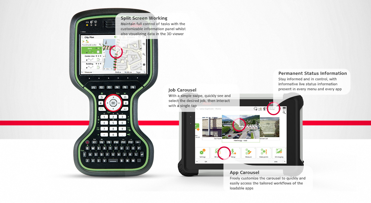
Leica Captivate is based on over 20 years of field software research and development. With a focus on an enjoyable and fit-for-purpose user interface, a 3D viewer for “3D everything, 3D everywhere,” Leica Captivate improves the things you do every day by making all tasks as simple as possible. Watch our short video to discover why Leica Captivate is the answer to any project requirement.
Leica Captivate Tools for Easier and Efficient Fieldwork
Fast and Accurate Staking of Road Slopes and Surfaces with the Leica AP20 AutoPole
Keep connected with Leica Captivate cloud services
Leica Captivate – Auto Setup
Leica Captivate – Inventory
QA Leica Captivate Shapefile Export App
New plugin download page tools for connecting Autodesk Civil 3D or Revit directly
Be Captivated: Creating the Leica Captivate Experience
Leica Nova MS60 – Dynamic Lock
The Leica Captivate Experience continues: Interviews with our experts
Increase surveying productivity with Leica Captivate through imaging and augmented reality