


Leica TS20
Be ready for the robotic total station that defines the standard for productivity.
Leica iCON iCS20 & iCS50
Our new 3D measuring and staking tools simplify your work. Minimum effort, maximum accuracy.

Everton Stadium Construction Project
Laing O’Rourke’s digital methods of construction.

The Digital Twin Industry Report
Discover how digital twins enhance business outcomes, such as revenue growth, carbon reduction and proactive problem-solving, based on insights...

Leica Geosystems Training School
Comprehensive training courses with hands-on experience provide a better understanding...

Pure Surveying
Learn about our new surveying solutions to grow your business, training to upskill yourself or your team or just see what's new. Visit our brand new industry site.
Learn about our new surveying solutions to grow your business, training to upskill yourself or your team or just see what's new. Visit our brand new industry site.

Reporter 93 is here!
Discover how core surveying values drive geospatial intelligence and resilient progres
Discover how core surveying values drive geospatial intelligence and resilient progres

The role of surveyors in reality capture workflows
Surveyors are essential to reality capture workflows, ensuring digital models align with physical ground truth. While accessible geospatial tools allow non‑surveyors to capture data, professional surveyors provide the expertise needed for accuracy, compliance, and safety. Their role includes quality assurance, data validation, and adherence to industry standards such as RICS, TSA Client Guides, and Historic England specifications. By adopting innovations from Leica Geosystems—like advanced laser scanning and the AP20 AutoPole—surveyors deliver faster, safer, and more precise results across projects ranging from trade fit‑outs to heritage documentation. This case study highlights how surveyors bridge digital and physical worlds, prevent costly errors, and inspire confidence in geospatial decision‑making.
Surveyors are essential to reality capture workflows, ensuring digital models align with physical ground truth. While accessible geospatial tools allow non‑surveyors to...
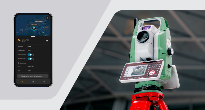
GeoCloud Protect
Advanced protection for advanced total stations
Advanced protection for advanced total stations
Leica iCON build software
From building foundations to topping out, Leica iCON build is the dedicated building construction software for layout, as-built and verification tasks on projects. Increase performance and productivity on site with an innovative software design, smart digital workflows, and an easy-to-understand interface purpose-built for construction professionals.
From building foundations to topping out, Leica iCON build is the dedicated building construction software for layout, as-built and verification tasks on projects. Increase...

Case Studies
Read how customers from around the world are putting our diverse solutions into action to shape smart change.
Read how customers from around the world are putting our diverse solutions into action to shape smart change.

Training
Comprehensive training courses with hands-on experience provide a better understanding empowering people and assets to be smarter, safer and more productive.
Comprehensive training courses with hands-on experience provide a better understanding empowering people and assets to be smarter, safer and more productive.

Mobile Mapping Hardware
Advanced sensor technology and intelligent simplicity meet in the Leica Pegasus TRK portfolio.
Advanced sensor technology and intelligent simplicity meet in the Leica Pegasus TRK portfolio.

Customer Support Services
A network of experienced professionals is there for you to expertly guide you through any problem, anywhere, anytime.
A network of experienced professionals is there for you to expertly guide you through any problem, anywhere, anytime.
Upcoming Events
Latest News
Contact Us
Leica Geosystems Limited
Hexagon House
Michigan Drive
Tongwell
Milton Keynes
MK15 8HT
Tel: +44 (0) 1908 513400
Fax: +44 (0) 1908 513401
If you are interested in press releases, customer magazines or you wish to give us feedback, please feel free to contact us.