


Precision “Where Every Inch Counts”: Defining Boundaries with Confidence

In land-scarce Singapore, accurate land boundaries are fundamental to urban governance. With limited space supporting housing, transport, and critical infrastructure, boundary certainty underpins confidence in land ownership, planning decisions, and long-term development. Maintained by the Singapore Land Authority, the national cadastral system defines every land parcel and strata lot through a unified geospatial reference framework, ensuring spatial consistency across agencies and projects (SLA, 2025)
Even minor boundary discrepancies can have far-reaching implications in such a highly regulated environment. Centimetre-level errors may affect development timelines, legal clarity, and inter-agency coordination, reinforcing why boundary accuracy is a prerequisite for sustainable urban management.
Measuring Boundaries in the Field
While cadastral boundaries are defined through legal instruments and certified plans, they must ultimately be verified on the ground. Surveying provides the link between legal definition and physical reality, translating mapped coordinates into permanent reference points within complex urban environments.
In Singapore, this verification process takes place under demanding field conditions shaped by high-rise construction, underground infrastructure, active traffic corridors, reflective surfaces, and restricted access. To ensure consistency and traceability across projects and over time, surveys are aligned to a national reference system comprising horizontal and vertical control networks and GNSS infrastructure. This common authoritative reference allows surveys conducted by different professionals and at different times to remain spatially consistent (SLA, 2025)
Technology Supporting Boundary Accuracy
Maintaining boundary accuracy in dense urban environments requires field instruments that can deliver stable and repeatable measurements under dynamic site conditions. Boundary verification often occurs on active construction sites, where environmental interference and human factors increase the risk of measurement error if not properly managed.
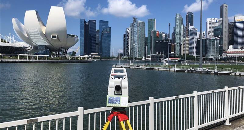
The Leica Nova TS16 supports boundary verification by enabling reliable prism tracking in such environments, reducing the impact of interference and operational error. By maintaining stable observations, the TS16 helps ensure that measurements captured in the field can be confidently translated into legal records and long-term cadastral datasets.
Accurate boundary verification, however, depends on more than total station observations alone. Survey markers form the foundation of all land and construction surveys in Singapore and are maintained and authorised by the Singapore Land Authority to ensure alignment with a consistent legal and spatial reference (SLA, 2025). To establish and verify these control points, surveyors rely on high-precision GNSS solutions such as the Leica GS18, which support efficient and reliable positioning even in dense urban environments where satellite visibility may be constrained.
Together, these technologies support an integrated workflow where control points are established with confidence and boundaries are verified with precision. The importance of such field technologies in sustaining boundary certainty has been highlighted in Singapore’s national reporting on land governance, including recent coverage by The Straits Times on the role of high-precision surveying in boundary verification activities.
Boundary Governance in Practice
Singapore’s cadastral framework is underpinned by a clear system of professional accountability. Under the Boundaries and Survey Maps Act, all cadastral survey plans submitted by Registered Surveyors are reviewed and approved before being incorporated into the national record.
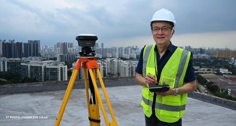
This responsibility sits with the Chief Surveyor, who ensures that boundaries are legally defined, unambiguous, and consistent nationwide. Each approved boundary contributes to a single, uniform spatial framework relied upon by agencies such as the Land Transport Authority and the Housing and Development Board for planning and development activities.
In a The Straits Times article published on 25 November in 2025, titled “Every Inch Counts”: He approves land boundaries in Singapore, Singapore’s longest-serving and former Chief Surveyor*, Mr Soh Kheng Peng, has noted that even small inaccuracies can escalate into significant disputes with long-term implications. His observation highlights how boundary surveying extends beyond measurement to encompass professional judgement, legal clarity, and public trust.

Boundaries Built on Precision and Trust
Boundary disputes can surface long after land has been developed, when small discrepancies become embedded in physical structures and legal records. In dense urban environments, such inconsistencies can have lasting consequences for ownership clarity, project delivery, and inter-agency coordination, reinforcing that boundary surveying is a core element of urban governance.
Experience from Singapore’s cadastral practice demonstrates how centimetre-level inaccuracies can escalate into complex disputes over time. Defensible boundary outcomes therefore require a careful balance of measurement precision, professional judgement, and regulatory clarity, supported by processes that allow decisions to be traced and justified long after surveys are completed.
Ultimately, in land-scarce cities, boundary certainty is defined not by precision alone, but by confidence in how measurements are interpreted, validated, and upheld over time. When governance frameworks, professional accountability, and reliable measurement technologies are aligned, boundaries become trusted foundations for sustainable urban development across generations.

Note:
Singapore’s longest serving and former Chief Surveyor, Mr Soh Kheng Peng, has served in the role since 2004 till 31 December 2025. Mr Victor Khoo has assumed the role of Singapore’s current Chief Surveyor, effective 1 January 2026.
If you would like to explore how high-precision surveying technologies can support accurate boundary verification in complex urban environments, our team would be happy to assist.
Learn how Leica Geosystems’ high-precision solutions enable reliable boundary verification.

Contact Leica Geosystems
Find your Leica Geosystems contact for sales, support and technical service.
Find your Leica Geosystems contact for sales, support and technical service.

Surveying and Engineering
Our flagship business for almost 200 years, we know the daily tasks of surveyors and engineers. Overcome challenges with our field-to-office solutions.
Our flagship business for almost 200 years, we know the daily tasks of surveyors and engineers. Overcome challenges with our field-to-office solutions.