Solutions for Public Safety, Security and Forensics

Public Safety Technology workfow

Our solutions enable professionals to fully capture the reality creating a Forensic Digital Twin and clear scenes quickly, reducing disruption, making digital documentation and mapping safer, minimising risks, protecting response teams and the public.

Covering an array of tasks, our solutions deliver the highest accuracy and provide the most qualified court-ready documentation. Partnering with police departments and investigative units, we support this critical work with a wide range of solutions, ranging from 3D laser scanners, total stations and GNSS to Forensic Software Suite.


Reality capture, mobile mapping, autonomous solutions and more

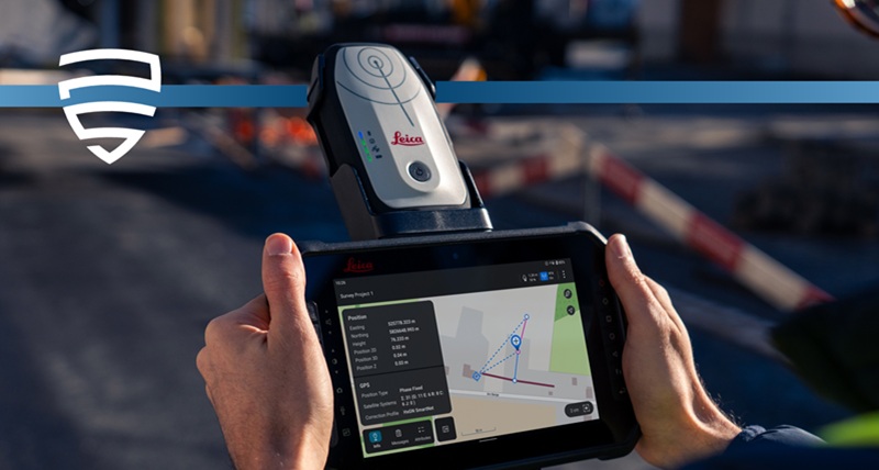
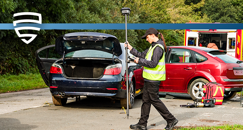
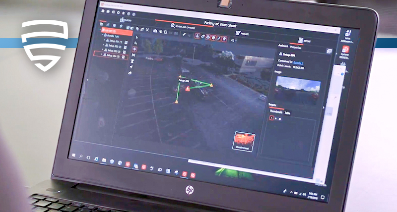
Our 3D laser scanning, autonomous solutions, mobile mapping, total stations and GNSS solutions enable you to completely capture and clear scenes quickly, making the digital documentation and mapping safer.

Software solutions to manage and create digital twins

Our specialised software creates a wide array of deliverables from digital datasets. Provide detailed and informative diagrams, illustrations, 3D animations, flythroughs and more.

Services and support

Access the largest library of high-resolution aerial imagery with the HxGN Content Program or benefit from the world’s largest GNSS correction service, HxGN SmartNet. Discover our tailored and scalable offering of after-sales services and support.

Contact our Public Safety, Security and Forensics experts

Highlighted solutions


With a wide array of fit-for-purpose-solutions, there are several options available to fit every workflow and budget. Improve safety onsite, speed of evidence gathering and deliver more accurate and comprehensive information with the right solution for you. Discover our featured solutions below.


Leica Zeno FLX100 plus: High-accuracy GNSS data collection for reliable scene documentation

Capture centimetre-level georeferenced data at crash, crime and disaster scenes using the rugged, compact Leica Zeno FLX100 plus smart antenna. Paired with Leica Zeno Mobile One, Leica’s latest intuitive mobile app for field data capture and connected via Zeno Connect, this solution enables safe, efficient collection of ground control points (GCPs), checkpoints and evidence locations, even in hard-to-reach or hazardous areas, thanks to tilt compensation. Zeno Mobile One ensures smooth field workflows with customisable data forms, offline mapping, and integration with Leica’s GNSS correction services. Field data can be synchronised with Zeno Office or exported to GIS, CAD, and photogrammetry platforms to validate drone-based reconstructions and produce legally defensible documentation.

Whether mapping a small scene or supporting a complex drone workflow, the FLX100 plus with Zeno Mobile One and Zeno Connect delivers fast, accurate, and court-ready results—making professional-grade spatial documentation accessible to every agency.


Leica Geosystems total stations + Leica Evidence Recorder: Data collection for incident reconstruction

Combined with the Evidence Recorder software, total stations can create scene mapping directly in the field. Whether you choose the Leica TS10, an entry-level total station with mostly two-person operation mode or, the Leica TS13, a scalable mid-range robotic total station for fast and reliable measurement, Evidence Recorder supports all common total stations, many of which can be controlled right from the Evidence Recorder interface.

Leica Evidence Recorder, a data collection software for incident reconstruction, allows users to create real-time 3D models to visualise complex scenes, review their measurements in 2D or 3D and confirm there are no errors or missing points before leaving the scene.


Leica GS18 I + Leica Infinity: Measure and clear scenes in minutes

Measure hundreds of previously inaccessible points from a safe distance in a matter of minutes, simply by walking around the scene. The dense point clouds derived from the photographs captured with the GS18 I's Visual Positioning technology provide centimetre-positioning quality that can aid in the visualisation of a crime or crash scene. Ensure completeness of evidence and revisit the scene from the office as needed to complete your investigation with confidence, thanks to the system’s ability to extract points either in the field or in the office.

Use Leica Captivate software to capture, measure and process data in the field, and Leica Infinity software to measure points or create a point cloud from the data back in the office conveniently on a larger screen and without disturbances from weather or moving objects.


Leica RTC360 + Leica Map360: Fast, agile, and precise scene documentation for court-ready deliverables

With the RTC360 3D laser scanner, scenes can be captured at up to 2 million points per second in less than two minutes and pre-registered at the scene. The RTC360 can also complete a double scan, automatically removing the noise usually generated by moving objects or vehicles through a scene.

Captured scan data is visualised and pre-registered directly in the field in real-time with the Cyclone FIELD 360 app, allowing users to check data completeness onsite. Quickly post-process 3D environments in the office with Cyclone REGISTER 360 software.

The data captured can be exported into the Map360, a scene diagramming and accident reconstruction software with an engineering-grade CAD engine and easy to use tools that enhance the quality of incident reconstructions and courtroom exhibits. Map360 helps you to import, process, analyse, visualise and create court-ready deliverables. Easily transform your 3D scene data into accurate and compelling Forensic Digital Twin.


Contact our Public Safety, Security and Forensics experts

Ezért válasszon minket

Közvetlen tanács, konzultáció és gyakorlati segítség. A köz- és magánszféra szervezeteinek olyan megbízható partnere vagyunk, amely megbízható szolgáltatás és szakértelem mellett a térinformatikai eszközök lehető legszélesebb portfólióját kínálja.

Alkalmazások

Szaktudásunk világszerte szolgálja a közbiztonsági szakembereket, és újradefiniálja azt, ahogyan a bűnüldöző szervek munkatársai az incidensek kivizsgálását és a helyszínelést, a bizonyítékgyűjtést és a bűnügyi térképezést kezelik.

Megoldások

A valóságrögzítést, a helyszínelést vagy a helyszín rekonstruálását, a pontos helymeghatározást és a helymeghatározási információkat célzó megoldásaink előnyt biztosítanak a Forensic Digital Twin (Kriminalisztikai digitális iker) megalkotásában.

Oktatási központ

Akár a hagyományos dokumentálási módszereken szeretne túllépni, akár a technológiát szeretné elsajátítani, képzési erőforrásaink a napi munkája minden lépését támogatják.