Ensuring safety and stability: Post-earthquake monitoring in Türkiye

Authors: Özgür Avci - Sistem A.Ş., Michelle Zeller, Megan Hansen
On 6 February 2023, two major earthquakes with magnitudes of 7.8 and 7.5 struck southern and central Türkiye. These earthquakes were among the strongest ever recorded in the country’s history, affecting 10 provinces across 350,000 km. As emergency responders raced against time to locate survivors, the structural instability of damaged buildings posed risks and threatened to hinder search progress.
In response, the monitoring technology experts at Sistem A.Ş. rushed to the hard-hit Kahramanmaraş province to deploy advanced structural monitoring technology from Leica Geosystems. By leveraging high-accuracy measurement sensors and monitoring software for automation and analysis, Sistem A.Ş. provided real-time insights into building movements and stability. This critical information enabled rescue teams to assess risks effectively and carry out operations with greater safety.
Challenges in search and rescue operations
The initial hours and days were the most critical period in the search and rescue operations. The teams had to work tirelessly around the clock in search of any sign of life, but this didn’t come without risks. Rescue operations were carried out in rubble, partially damaged buildings, and structures affected by the earthquake. Even when damage hadn’t led to collapse, many buildings’ structural integrity had been severely compromised, posing significant danger to the rescue teams.
Alongside the people on the ground, rescue teams deployed heavy construction machinery to assist in lifting concrete blocks or removing unsafe sections of damaged structures. These machines, however, often had to operate near fragile, unstable structures, where their vibrations could trigger further movement or pose additional risks to the already compromised buildings. Therefore, deploying a trusted Leica Geosystems deformation monitoring system to understand the structural health of these buildings was vital to keeping the rescue teams and equipment on-site safe.
Supporting rescue with structural health monitoring
Advanced monitoring solutions allow rescue personnel to detect potential structural risks, safely manage activities, and make informed decisions. To monitor the structural health of buildings impacted by the earthquake, Turkish government organisations coordinated with the surveying team from Sistem A.Ş.
Using the Leica GeoMoS monitoring solution, Sistem conducted remote monitoring from a safe distance, eliminating the need for physical contact with the compromised buildings and structures. Real-time information allowed rescue leaders to briefly pause operations to monitor movements and assess whether it was safe to proceed once stability was confirmed.
To meet these requirements, the monitoring setup had to function independently of external power sources while reliably transmitting data for real-time analysis.

The Leica GeoMoS monitoring solution
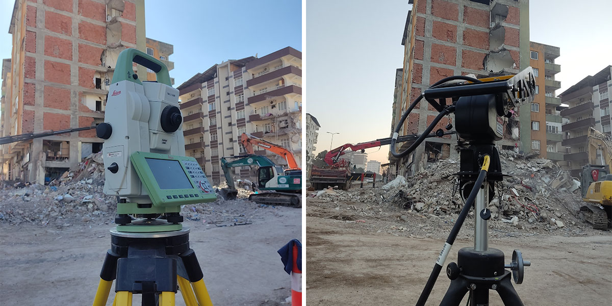
Integrated into the Leica GeoMoS ecosystem, Leica TS16 total stations provided an automated structural monitoring solution. Using the TS16’s built-in camera, operators could control and pilot the total station via GeoMoS and position it to monitor points remotely, staying out of the danger zone.
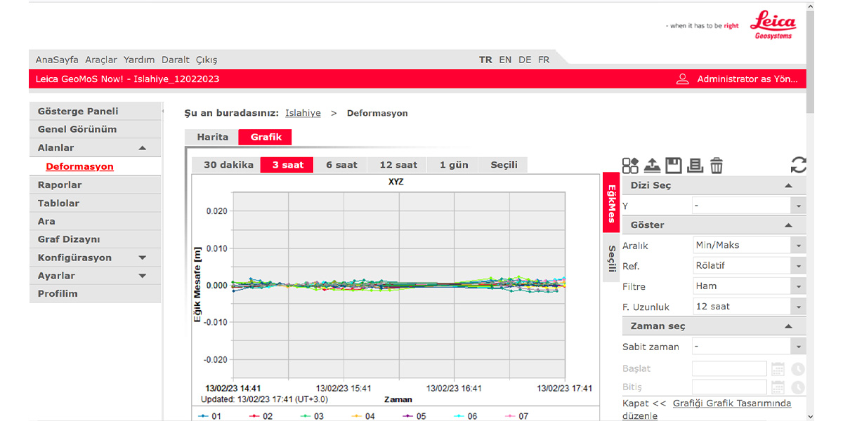
The monitoring team first defined points on the structures requiring observation and then used GeoMoS to carry out automated monitoring by repeatedly measuring survey control and monitoring array points in predefined sequences. Graphs and data reports were then automatically generated and made accessible via the Leica GeoMoS Now! web interface.
Complementing this data, the monitoring team also used the IDS GeoRadar HYDRA-G ground-based interferometric radar for real-time remote sensing of surfaces. By combining the TS16’s high-accuracy measurements of precise, discrete points on structures with radar data detecting changes in the phase of reflected signals across larger areas, the team increased coverage and allowed cross-verification.
By leveraging these technologies, rescue coordinators could closely monitor any signs of instability in the buildings and structures, make rapid decisions to halt or proceed with rescue operations, and reduce the safety risk to personnel and volunteers on the ground. This real-time, non-intrusive remote monitoring allowed the teams to adapt their strategies instantly in response to even the slightest structural changes.

Next level monitoring with scanning total stations
For certain structures, where measuring points alone does not adequately capture movements occurring, Sistem used the Leica MS60 MultiStation to collect more data. The MS60 combines the full functionality of a total station with a highly accurate laser scanner, enabling both precise point measurements and comprehensive scanning.
Connected to Leica GeoMoS, the MS60 scanned surfaces every few minutes and sent the data to GeoMoS Monitor for processing. The GeoMoS Now! visualisation platform then generated real-time displacement graphs, providing detailed insights into surface movements across the structure. The system merges colour-scaled visualisations onto images of the structure to present movement in a clear and easily understandable way.
Additionally, the MS60’s IP65-rated environmental protection ensured that it remained operational in heavy rain and dusty conditions, eliminating the need for the engineers on the ground to pack up or shelter the instrument during adverse weather.

Real-time insights and post-rescue applications
Leica Geosystems monitoring solutions were invaluable during rescue operations. Managers on-site reported that having access to real-time insights on structural movements enhanced their sense of safety and enabled their teams to work more efficiently, confidently, and with greater focus.
Beyond the immediate rescue phase, the utility of these solutions continued as aftershocks posed ongoing risks to weakened structures. Instruments like the MS60 scanning total station and TS16 total station were crucial for continuous monitoring. Their portability and ease of deployment enabled authorities to swiftly relocate them as needed, maintaining vigilance and prioritising safety throughout the recovery phase.
Ensuring long-term safety
Automated monitoring solutions are essential for both immediate response and long-term safety following disasters. By delivering precise, real-time data, these systems enable continuous measurements to analyse compromised structures, particularly in the aftermath of events like earthquakes and during subsequent aftershocks. Their ability to operate remotely and adapt to changing conditions allows authorities to effectively manage risks, protect residents and workers, and support recovery efforts.
Advanced monitoring solutions after the earthquakes in Turkey played an essential role in disaster response, enabling informed decisions that enhance personnel safety. The experience in Kahramanmaraş shows how structural health monitoring, as part of a comprehensive recovery strategy, can help communities manage the challenges posed by natural disasters, ensuring a safer and more resilient recovery process.


