


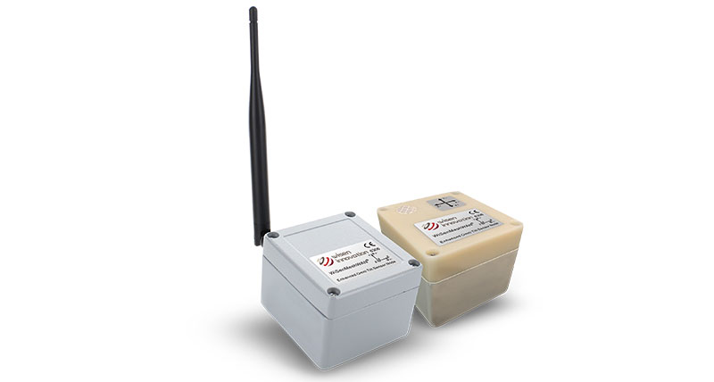
WiSen Wireless Geotechnical Monitoring Systems
Simple installation. Minimal configuration. Easy automation.

The WiSenMeshWAN® system offers wireless dynamic and autonomous data acquisition from geotechnical sensors using edge technology. Automated geotechnical sensor measurement, which utilises long range wireless radio nodes and a SmartGateway, allows you to focus on more challenging tasks instead of manual data acquisition and logging.
WiSenMeshWAN® sensor nodes are transmitters and receivers that create a self-forming dynamic radio mesh network which sends data to a SmartGateway. Users have full, remote control over the system via direct, triggered, or scheduled changes enabling dynamic measurement and reporting rates from 1Hz to twice a week.
WiSenMeshWAN® product portfolio is fully compatible with Leica Geosystems’ and Hexagon’s monitoring solutions enabling data 24/7 for incorporation into Leica GeoMoS or HxGN GeoMonitoring Hub monitoring software.
Form an extensive understanding with a complete monitoring solution and create homogeneous systems using geodetic, geotechnical & InSAR data.


Minimal configuration, maximum integration
Sensors are plug and play, working straight out of the box with a self-configuring radio network. Multiple interface options allow for integration with 3rd party sensors from leading geotechnical manufacturers (analog / digital / vibrating wire interface).
Self-reliant system
Designed for up to 10 years of maintenance-free use, units are rated IP65 and above with internal power and radio. With their robust industrial enclosures, the units can be mounted in multiple ways, catering to varying needs of your monitoring projects.
Dynamic measurement and reporting
Connected geotechnical sensors and nodes automatically measure and report data at user defined intervals from once a second to twice a week. Configure your system to read at different intervals for specific time periods or change the reading interval based on trigger events.
Wireless sensor network
A fully automated, encrypted, long-range radio network capable of up to 1.5 km between nodes and using data hop technology makes monitoring data collection easy. Add in dynamic radio transmission routing and ground penetration for further enhancement. Data hopping wireless networks are robust yet easy to use for reliable monitoring data acquisition.

WiSenMeshWAN - SmartGateway & SmartGateway Mini data sheet
WiSenMeshWAN - Interface Node (Analog) data sheet
WiSenMeshWAN - Interface Node (Digital) data sheet
WiSenMeshWAN - Omni Tilt & Tilt R Node data sheet
WiSenMeshWAN - Omni Tilt & Distance Node data sheet
WiSenMeshWAN - Interface Node (Vibrating Wire) data sheet
Leica Geosystems monitoring solutions brochure
The solution overview for:
Monitoring in urban areas
Monitoring for railway
Monitoring for construction sites
Monitoring for tunnels
Monitoring of slopes and landslide areas
Monitoring for preservation of heritage structures
Monitoring for dams and reservoirs
Monitoring of large-scale infrastructure
Monitoring for highways
Software & Service:
- Leica GeoMos Now! workflow service
- Leica GeoMoS Adjustment software
- Leica GNSS Spider software
- Leica CrossCheck GPS/GNSS deformation monitoring service
- Leica SpiderQC GNSS data analysis software
- HxGN GeoMonitoring Hub
Hardware:
- Leica Nova TM60 robotic total station
- Leica ComBox60 for monitoring communication
- Leica GMX910 SmartAntenna
- Leica GM30 GNSS receiver for monitoring

Contact us about Monitoring
Get in contact with us for more information about our monitoring solutions.
Get in contact with us for more information about our monitoring solutions.

Leica GeoMoS
Flexible automatic deformation monitoring software solution.
Flexible automatic deformation monitoring software solution.

Leica Nova TM60 Monitoring Total Station
Meet Leica Nova TM60, the total station for permanent and campaign monitoring projects.
Meet Leica Nova TM60, the total station for permanent and campaign monitoring projects.

Leica M-Com
First plug and play solution for monitoring.
First plug and play solution for monitoring.

Combining Sensor Data for Comprehensive Monitoring
By supporting data from all third-party sensors, the Leica GeoMoS AnyData Import feature ensures more effective data collection in monitoring schemes.
By supporting data from all third-party sensors, the Leica GeoMoS AnyData Import feature ensures more effective data collection in monitoring schemes.