


Detection Educational Articles & Expert Insights
Health and safety for excavations
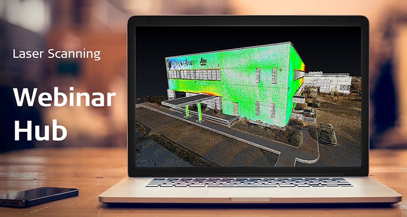
The Leica RTC360 3D laser scanner is highly portable, highly automated, intuitive and designed for maximum productivity spanning many industries. This laser scanning solution efficiently combines a high-performance scanner with a mobile-device app to capture and automatically register scans in real time and industry-leading post-processing office software to register scans seamlessly to complete your entire workflow.

Got questions? We've got the answers!
Our global 3D laser scanning experts are here to answer your questions.
Ground Penetrating Radar, A Step-By-Step Walkthrough Of The Leica DSX Detecting Utilities
The Leica DSX does all the heavy lifting, by interpolating the ground penetrating radar results, through a set of sophisticated computational algorithms. Whether you are performing utility repair and maintenance, civil engineering and surveying companies, the Leica DSX utility detection solution allows even beginners to look like pros with its intuitive software interface.
Case Studies

What is Detection?
Join the Leica Geosystems Utility and GPR expert, Steve Davies, taking you through the basis for a good detection workflow.
Join the Leica Geosystems Utility and GPR expert, Steve Davies, taking you through the basis for a good detection workflow.

Utility Detection Survey - Project from A to Z
Join Steve Davies, Detection Expert in a webinar on how a project needs to be planned to and executed to get the best results.
Join Steve Davies, Detection Expert in a webinar on how a project needs to be planned to and executed to get the best results.

Utility Detection Survey - Project from A to Z - GPR
Join Detection Expert, Steve Davies in the second part of the webinar series from planning through to execution of a utility survey project to get the best results from EML and GPR.
Join Detection Expert, Steve Davies in the second part of the webinar series from planning through to execution of a utility survey project to get the best results from EML and GPR.
How to best protect buried assets
Andrew Allen, utility detection product manager explains a comprehensive approach for protecting underground utilities
Andrew Allen, utility detection product manager explains a comprehensive approach for protecting underground utilities


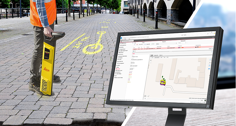
Simple way to uncover utilities and reduce utility strikes with Leica DSX
Learn how the disruptive DSX utility detection solution in simple way helps to reduce utility strikes and brings additional layer of safety and efficiency by integrating into excavation and survey workflows.
Learn how the disruptive DSX utility detection solution in simple way helps to reduce utility strikes and brings additional layer of safety and efficiency by integrating into excavation and survey workflows.

Understanding GPR
Locating underground utilities without breaking ground can be a headache, especially in challenging environments.
Locating underground utilities without breaking ground can be a headache, especially in challenging environments.

GPR Systems & Their Use
Locating underground utilities without breaking ground can be a headache, especially in challenging environments.
Locating underground utilities without breaking ground can be a headache, especially in challenging environments.
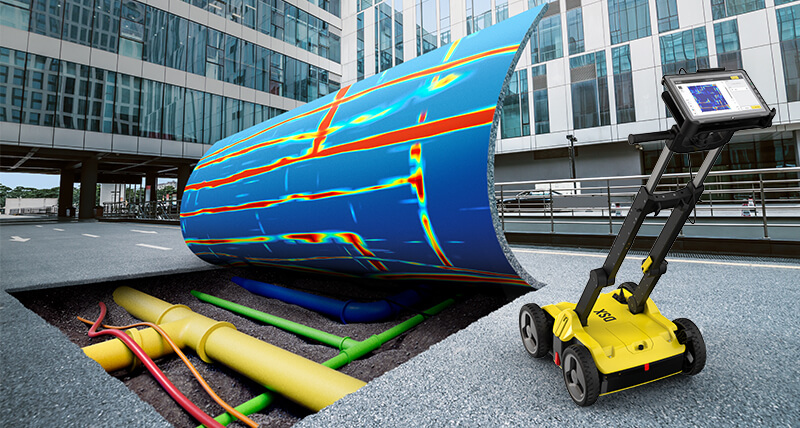
Ground Penetrating Radar for everyone with Leica DSX
The newly-announced Leica DSX utility detection solution is about to democratise GPR technology, bringing it to less experienced users
The newly-announced Leica DSX utility detection solution is about to democratise GPR technology, bringing it to less experienced users

Detection Educational Articles & Expert Insights
Take no risk and prevent utility strikes. Discover detection solutions that increase health and safety of crew on-site and minimise downtime and unplanned costs during excavation works.
Take no risk and prevent utility strikes. Discover detection solutions that increase health and safety of crew on-site and minimise downtime and unplanned costs during excavation works.

Ground Penetrating Radar, A Step-By-Step Walkthrough Of The Leica DSX Detecting Utilities
Get a step-by-step walkthrough of how easy it is to unlock the power of ground penetrating radar and detect utilities with the Leica DSX Utility Detection Solution.

Meet the underground utility detection expert
Andre Fischer, utility detection specialist at Leica Geosystems, explains how you can detect faster, safer and simpler underground utilities at Bauma.

Utility Detection Made Easier, Faster, and Safer
Leica's DSX utility detection solution, consisting of a portable hardware with intuitive software, allows users to easily locate and visualise utilities.

GPR for Everyone: Easy Utility Mapping and Detection
The use of Ground Penetrating Radar (GPR) technology has been limited to highly skilled professionals trained on interpreting radargrams.
Case Studies


