Investigación Avanzada de Incendios y Explosiones
Cuando todo está cubierto de hollín y ennegrecido por el fuego y el humo, ¿cómo se puede documentar con precisión la escena de un incendio o una explosión?
Gracias a nuestra tecnología, puede recopilar de forma rápida y segura información interpretativa crucial para investigar y esclarecer las circunstancias. Nuestras soluciones ayudan a mantener la seguridad de los equipos de respuesta en el lugar de los hechos y documentan de forma integral los pasos dados al inicio de la investigación de un incendio. La aplicación de procedimientos estandarizados con soluciones fiables le ayudará a obtener información valiosa sobre el curso de los acontecimientos y a reconstruir lo sucedido, incluso en los casos en los que el tipo y el alcance de su investigación varía de un caso a otro.
Contacte con nuestros expertos en Seguridad Pública, Seguridad e Investigación Forense
Proteja la escena de un incendio y controle la seguridad de los equipos de respuesta
Las operaciones de rescate que se llevan a cabo tras un incendio son las tareas más difíciles y complejas que realizan las unidades de rescate. La seguridad es primordial cuando una estructura puede haberse derrumbado o está a punto de hacerlo. Cuando dichas unidades llegan al lugar del suceso, su primera tarea importante es efectuar un reconocimiento exhaustivo.
Es necesario analizar la estabilidad de la estructura y, en caso necesario, supervisar las estructuras en todas las operaciones (por ejemplo, con nuestras estaciones totales Leica Geosystems y nuestra solución GeoMoS) para aumentar la seguridad de los equipos de respuesta.
Documente escenas de incendios o de explosiones en condiciones difíciles
La seguridad es la primera preocupación en la escena de un incendio. La escena de un incendio o una explosión presenta un factor de riesgo elevado, pues existen peligros como materiales calentados, derrumbes estructurales, redes eléctricas y de gas dañadas y escombros, así como amianto, productos de combustión peligrosos y otras sustancias tóxicas.
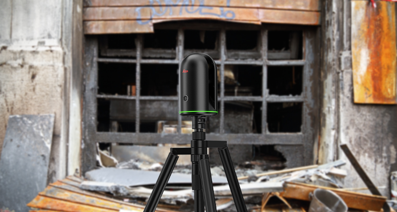
El uso del escáner láser de imágenes BLK360, con su función incorporada de imagen térmica que muestra mapas de calor en el lugar del incendio, permite reducir los riesgos para las unidades que entran en el edificio, rescatan a las víctimas y documentan la escena. La extensión de la estructura o del edificio y los factores ambientales pueden desempeñar un papel decisivo.
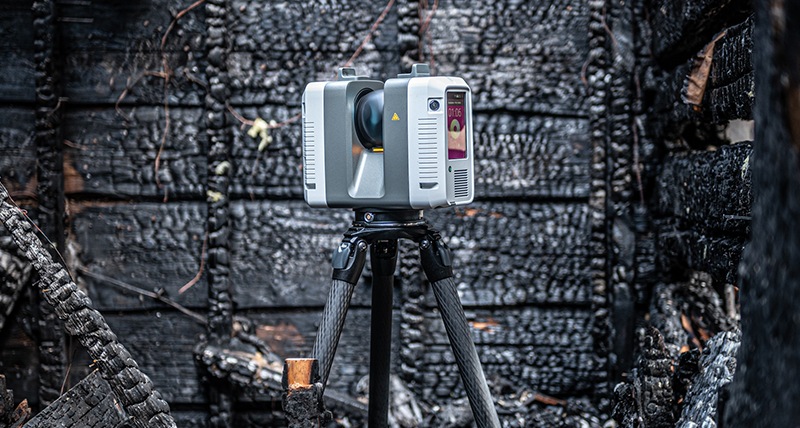
Las estructuras grandes o complejas se capturan mejor con el escáner láser RTC360. Este dispositivo versátil y robusto (IP54) es una herramienta ideal para la captura de datos en exteriores y en condiciones meteorológicas adversas.
Conserve la escena del incendio, visualice los detalles en Realidad Virtual (RV) y forme a su personal en cualquier momento y en cualquier lugar
Cree entornos de realidad virtual realistas a partir de datos de vehículos aéreos no tripulados (UAV) o nubes de puntos 3D para permitir una nueva visita digital a las escenas de incendios o explosiones. Incluya imágenes de las pruebas, informes en PDF, datos en 2D o anotaciones y, después, desarrolle entornos de formación inmersivos con escenarios virtuales flexibles adaptados a sus necesidades. La inmersión en el mundo digital y la interacción de los usuarios potenciada por la incorporación de estímulos hápticos o auditivos, el punto de vista en primera persona y la sensación de «presencia», completan las ventajas de la formación virtual.
Proporcione a sus unidades, sus equipos y su personal de respuesta un entorno de aprendizaje de realidad virtual personalizado, ya sea para la formación dirigida por un instructor o para itinerarios de aprendizaje remoto y adaptado al ritmo de cada uno.
Descubra nuestras soluciones recomendadas para la investigación avanzada de incendios y explosiones
Documentación rápida, ágil y precisa de escenas de incendios y mapeo forense para obtener resultados aptos para los tribunales

Documente la escena con el Leica RTC360
El escáner láser 3D RTC360 permite capturar escenas de incendios o explosiones a una velocidad de hasta 2 millones de puntos por segundo en menos de dos minutos directamente en el lugar del suceso.
El RTC360 permite capturar fácilmente detalles y matices muy precisos y relaciones espaciales de forma rápida y exhaustiva y con una precisión milimétrica, independientemente de las condiciones ambientales y del alcance del lugar.

Gestione los datos con Leica Cyclone FIELD 360 y Leica Cyclone REGISTER 360
Los datos de escaneo capturados se muestran y se registran previamente, directamente sobre el terreno y en tiempo real, con la aplicación Cyclone FIELD 360, lo que permite a los usuarios realizar controles de calidad y garantizar la exhaustividad de los datos.
Realice un post-procesamiento rápido de entornos 3D en la oficina utilizando el software Cyclone REGISTER 360.

Genere una amplia gama de informes con Leica Map360
Nuestro software de mapeo forense, Map360, puede reunir los datos de escaneo recopilados, por ejemplo, con imágenes de grabaciones de circuito cerrado, así como otros documentos pertinentes, para integrarlos directamente en modelos para el análisis y la formulación de hipótesis. Los resultados del análisis de datos pueden consultarse fácilmente desde los ordenadores del laboratorio de investigación criminal/de incendios o desde cualquier otro lugar, lo que ofrece un método fácil y accesible de volver a los detalles siempre que sea necesario, incluso semanas o meses después de producirse el incendio.
Map360 le ayuda a transformar fácilmente los datos en 3D de incendios y explosiones en un Gemelo Digital Forense preciso y convincente.
Captura de 360° de la realidad de la escena de un incendio en interiores, con un solo botón y utilizando imágenes térmicas

Capture la escena con el Leica BLK360
El BLK360 captura el entorno en 3D con imágenes panorámicas a todo color que superponen sobre una nube de puntos altamente precisa. Con un peso de solo 1 kg, el BLK360 es el instrumento más pequeño y ligero de su clase y es fácil de usar gracias que funciona con un solo botón. Cualquier persona capaz de manejar una tableta puede capturar ahora el mundo que se encuentra a su alrededor con imágenes panorámicas en 3D de alta resolución.
El BLK360 es capaz de obtener imágenes térmicas gracias a su sensor de imágenes térmicas incorporado. Cada escaneo incluye una panorámica de la imagen térmica, que le permite ver las temperaturas dentro de dicho escaneo con una escala de colores y capturar las unidades de energía en caso de tratarse de la escena de un incendio o una explosión.

Gestione y proporcione los datos con Leica Cyclone FIELD 360 y Leica Cyclone REGISTER 360 (edición BLK)
Utilizando la aplicación para dispositivos móviles Cyclone FIELD 360, el BLK360 transmite los datos de las imágenes y las nubes de puntos a un iPad, o bien los datos del proyecto final a Cyclone REGISTER 360 o a Cyclone REGISTER 360 (edición BLK) utilizando una conexión Wifi. Gracias al procesamiento de imágenes y nubes de puntos sobre la marcha en el campo, así como a los flujos de trabajo de oficina de registro automático que ofrecen ambas aplicaciones de software, el BLK360, combinado con la solución de software de su elección, agiliza enormemente los procesos de captura de la realidad, por lo que esta tecnología es accesible para todos.
Vigilancia estructural para operaciones automatizadas de seguridad y rescate en la escena de un incendio

Supervise los movimientos con las estaciones totales de Leica Geosystems y una aplicación específica
Con una estación total de Leica Geosystems y una aplicación incorporada, los movimientos de las estructuras pueden controlarse de forma automática y precisa, tanto de día como de noche, para garantizar la seguridad de los equipos de respuesta a incidentes y la de las víctimas.

Supervise los movimientos de forma continua utilizando el software Leica GeoMoS y las estaciones totales de Leica Geosystems
Además, en el caso de las estructuras que deben vigilarse durante un periodo de tiempo más largo, es posible incorporar un sistema de supervisión automático. Formado por una estación total Leica y un software de control Leica GeoMoS en la propia escena, es posible detectar cualquier movimiento de la estructura en cualquier momento del día. Las notificaciones de movimiento se envían automáticamente para informar a los interesados y garantizar su seguridad.


