


Enquêtes approfondies sur les incendies et les explosions

Lorsque tout est recouvert de suie et est devenu noir sous l'effet du feu et des fumées, comment documenter avec précision les lieux d'un incendie ou d'une explosion ?
Notre technologie vous permet de collecter de façon rapide et sûre des informations d'interprétation cruciales pour analyser et éclaircir les circonstances. Nos solutions contribuent à assurer la sécurité des équipes d'intervention sur les lieux et à documenter complètement les mesures prises sur les lieux d'un incendie. L'intégration de procédures standard avec des solutions fiables, vous aide à collecter de précieuses informations sur le cours des événements et à reconstituer les faits, même si le type et l'étendue de votre enquête varient en fonction des cas.
Contactez nos experts en sécurité publique, sécurité et forensique

Sécurisez les lieux de l'incendie et veillez à la sécurité des équipes d'intervention
Les opérations de sauvetage effectuées après un incendie font partie des tâches les plus compliquées et complexes des unités de secours. La sécurité est primordiale lorsqu'une structure s'est déjà effondrée ou est sur le point de le faire. Lorsque l'unité de secours arrive sur les lieux, sa première tâche importante consiste à effectuer une reconnaissance exhaustive.
La stabilité de la structure doit être analysée. La surveillance structurale effectuée si nécessaire tout au long de l'opération (par exemple avec les stations totales Leica Geosystems et la solution GeoMoS), renforce la sécurité des équipes sur le terrain.

Documentez les lieux d'incendie ou d'explosion dans des conditions difficiles
La sécurité est la plus haute priorité sur les lieux d'un incendie. Une scène d'incendie ou d'explosion expose à des risques plus élevés, notamment en relation avec les matériaux brûlés, l'effondrement structural, l'endommagement de réseaux d'électricité et de gaz, les débris, l'amiante, les produits de combustion dangereux et d'autres substances toxiques.
Avec sa fonction d'image thermique qui montre les zones de chaleur sur les lieux de l'incendie, le scanner laser imageur BLK360 aide à réduire les risques pour les unités entrant dans le bâtiment, sauvant les victimes et documentant la scène. Le périmètre de la structure ou du bâtiment et les facteurs environnementaux peuvent jouer un rôle important.
Le scanner laser RTC360 est idéal pour relever des structures étendues ou complexes. Le scanner polyvalent et robuste (IP54) est un outil parfait pour relever des données à l'extérieur dans des conditions météorologiques défavorables.

Préservez les lieux d'incendie, visualisez les détails grâce à la réalité virtuelle (RV) et formez votre équipe à tout moment et en tout lieu
Créez des environnements de réalité virtuelle photoréalistes à partir de données UAV ou de nuages de points 3D, pour pouvoir revisiter les lieux d'un incendie ou d'une explosion dans la réalité numérique. Incluez des images d'éléments de preuve, rapports PDF, données 2D ou annotations, et développez des environnements de formation réellement immersifs avec des scénarios virtuels flexibles, en fonction de vos besoins. L'immersion dans le monde numérique et l'interaction des utilisateurs, enrichies par des stimuli haptiques ou audio, l'égo-perspective et la sensation de « présence », complètent les avantages de la formation virtuelle.
Offrez à vos unités, vos équipes et à votre personnel d'intervention, une expérience d'apprentissage RV adaptée, en présentiel ou à distance, les cours en ligne permettant à chaque personne d'avancer à son rythme.
Découvrez nos solutions recommandées pour les analyses avancées d’incendies et d’explosions
Documentation et cartographie forensique de lieu d’incendie, rapides, flexibles et précises, pour des livrables judiciaires

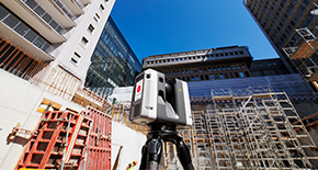
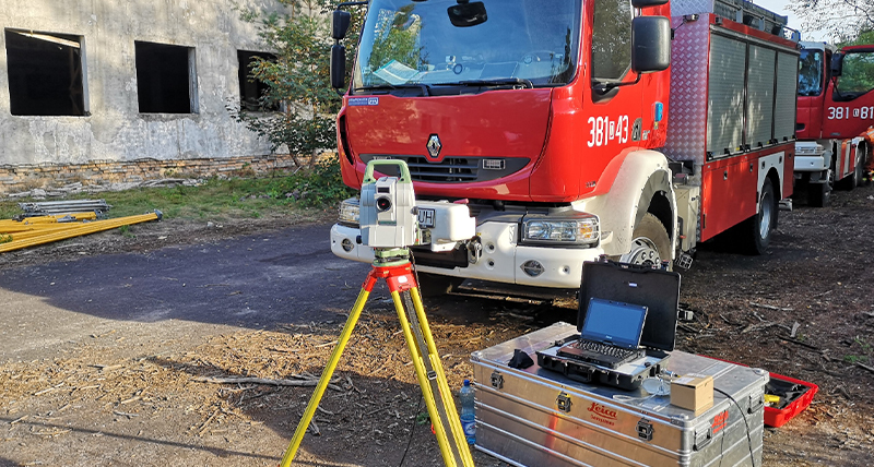
Documentez la scène avec le Leica RTC360
Le scanner laser 3D RTC360 permet de relever en moins de deux minutes des lieux d’incendie ou d’explosion avec jusqu’à 2 millions de points par seconde, directement sur le site.
Le RTC360 peut facilement enregistrer des détails fins et relations géospatiales, de façon rapide, complète et avec une précision millimétrique, indépendamment des conditions environnementales et de l’étendue du site.
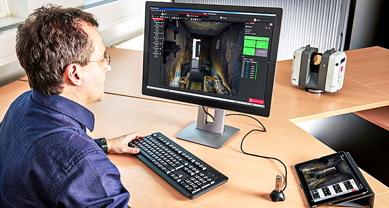
Gérez les données avec les logiciels Leica Cyclone FIELD 360 et Leica Cyclone REGISTER 360
Les données de scan relevées sont visualisées et préassemblées directement sur le terrain en temps réel avec l’application Cyclone FIELD 360, permettant aux utilisateurs de vérifier la qualité et l’exhaustivité des données sur le site.
Post-traitez rapidement des environnements 3D au bureau avec le logiciel Cyclone REGISTER 360.

Fournissez un vaste ensemble de rapports avec Leica Map360
Notre logiciel de cartographie forensique Map360 peut intégrer les données scannées directement avec, par exemple, des enregistrements CCTV, images et autres documents importants, dans des modèles pour les analyses et hypothèses. Les résultats de l’analyse de données sont facilement accessibles à partir d’ordinateurs installés dans le laboratoire de criminalistique/feu ou ailleurs, et permettent ainsi de retrouver aisément des détails si cela est nécessaire, même des semaines ou des mois après l’événement.
Map360 vous aide à transformer facilement vos données d’incendie et d’explosion 3D en jumeau numérique forensique précis et clair.
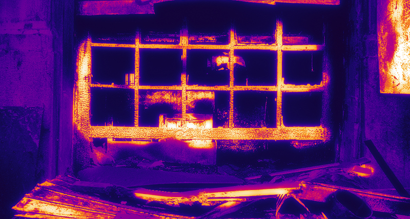
Capture de la réalité d’un lieu d’incendie intérieur sur 360°, avec un seul bouton et des images thermiques
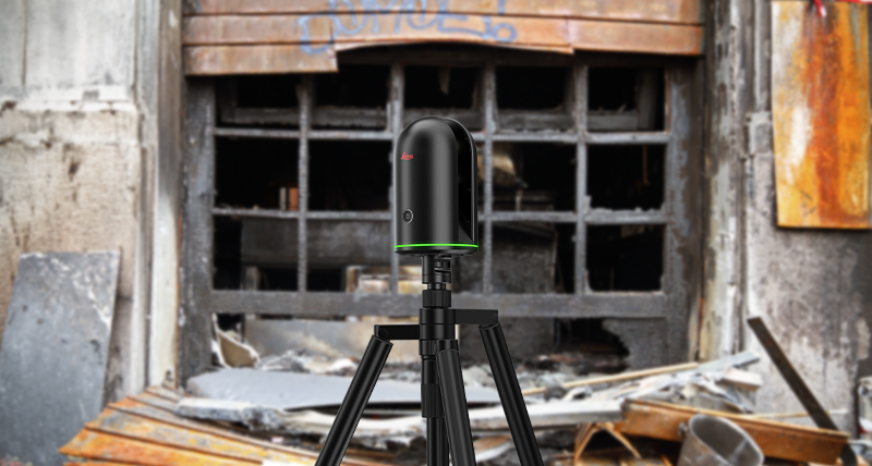
Relevez le lieu avec le Leica BLK360
Le BLK360 relève l’environnement en 3D avec des images panoramiques pleines couleurs superposées sur un nuage de points de haute précision. Pesant seulement 1 kg, le BLK360 est l’instrument le plus petit et le plus léger de ce type. Il est aussi très facile à utiliser grâce à la commande à un bouton. Toute personne sachant utiliser une tablette, peut maintenant relever l’environnement avec des images panoramiques 3D de haute résolution.
Le BLK360 est capable de réaliser des images thermiques grâce au capteur intégré correspondant. Chaque scan inclut une image thermique panoramique, permettant de visualiser les températures sur le scan avec une échelle de couleurs et de relever les unités d’énergie pour les lieux d’incendie ou d’explosion.
Gérez et fournissez les données avec les logiciels Leica Cyclone FIELD 360 et Leica Cyclone REGISTER 360 (BLK Edition)
Avec l’application d’appareil mobile Cyclone FIELD 360, le BLK360 transmet des données d’image et de nuage de points à un iPad, ou des données-projet finales aux logiciels Cyclone REGISTER 360 ou Cyclone REGISTER 360 (BLK Edition) via Wi-Fi. Avec le traitement d’images et de nuages de points sur le terrain et l’auto-assemblage proposés dans les deux offres de logiciel, le BLK360 et la solution logicielle de votre choix rationalisent la procédure de capture de la réalité en mettant cette technologie à la portée de tous.
Surveillance structurale pour des mesures de sécurité et de sauvetage automatisées sur le lieu d’un incendie
Surveillez les mouvements avec les stations totales de Leica Geosystems et une application spéciale
Avec une station totale Leica Geosystems et une application intégrée, les mouvements de structures peuvent être surveillés de façon automatique et précise, de jour et de nuit, pour garantir la sécurité des équipes d’intervention et victimes sur place.
Surveillez en continu les mouvements avec le logiciel Leica GeoMoS et les stations totales Leica Geosystems
Pour les structures devant être surveillées sur une longue durée, un système de surveillance automatisé peut être établi. Constitué d’une station totale Leica et du logiciel d’auscultation Leica GeoMoS, cet équipement est en mesure de détecter en continu tout mouvement de la structure. Les notifications de mouvement sont automatiquement envoyées aux parties prenantes pour les informer sur la sécurité.
Contactez nos experts en sécurité publique, sécurité et forensique

Analyse des lieux d'un incendie avec le scanner laser Leica RTC360
Découvrez pourquoi le RTC360 s'est révélé être le meilleur outil pour la documentation et l'analyse forensique dans le département de police de Dubaï, en améliorant les procédures d'enquête sur les incendies et les explosions.
Découvrez pourquoi le RTC360 s'est révélé être le meilleur outil pour la documentation et l'analyse forensique dans le département de police de Dubaï, en améliorant les procédures d'enquête sur les incendies et les explosions.

Transformer la réalité en réalité virtuelle photoréaliste grâce à la numérisation laser
En utilisant le RTC360, le concepteur de RV RiVR a réussi à développer des environnements virtuels réalistes, utilisés pour former de futurs pompiers et policiers.
En utilisant le RTC360, le concepteur de RV RiVR a réussi à développer des environnements virtuels réalistes, utilisés pour former de futurs pompiers et policiers.

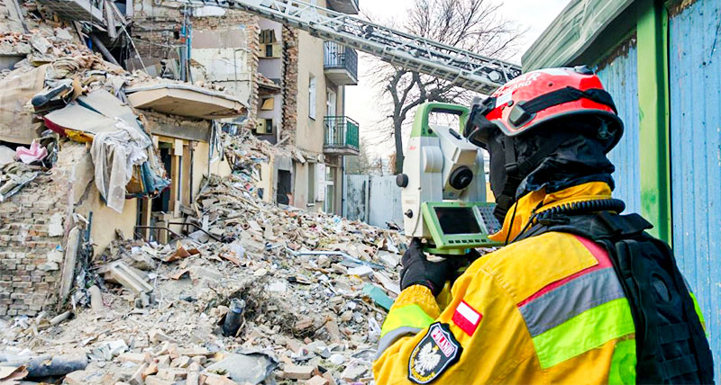
Surveillance de la déformation après un incendie avec les stations totales Leica Geosystems dans le service des pompiers polonais.
Les opérations de secours en cas d’incendie ou d’explosion ou en cas d’endommagement de constructions, sont les tâches les plus compliquées, complexes et dangereuses.
Les opérations de secours en cas d’incendie ou d’explosion ou en cas d’endommagement de constructions, sont les tâches les plus compliquées, complexes et dangereuses.

Pourquoi nous choisir
Conseil de pair à pair, consultation et assistance pratique. Nous sommes un partenaire de confiance aussi bien du secteur public que du secteur privé, et proposons le plus grand éventail d’outils géospatiaux, de services fiables et de compétences.
Conseil de pair à pair, consultation et assistance pratique. Nous sommes un partenaire de confiance aussi bien du secteur public que du secteur privé, et proposons le plus grand éventail d’outils géospatiaux, de services fiables et de compétences.

Applications
Notre savoir-faire aide les professionnels de la sécurité publique dans le monde entier. Il redéfinit la manière dont les forces de l’ordre gèrent les enquêtes sur les lieux d’un incident, la collecte d’éléments de preuve et la cartographie forensique.
Notre savoir-faire aide les professionnels de la sécurité publique dans le monde entier. Il redéfinit la manière dont les forces de l’ordre gèrent les enquêtes sur les lieux d’un incident, la collecte d’éléments de preuve et la cartographie forensique.

Solutions
Nos solutions pour la capture de la réalité, les analyses ou reconstitutions de lieux, le positionnement précis et l’intelligence spatiale, vous offrent un net avantage dans la création d’un jumeau numérique forensique.
Nos solutions pour la capture de la réalité, les analyses ou reconstitutions de lieux, le positionnement précis et l’intelligence spatiale, vous offrent un net avantage dans la création d’un jumeau numérique forensique.

Centre de formation
Que vous décidiez d’aller au-delà des méthodes de documentation traditionnelles ou de maîtriser votre technologie, nos ressources de formation vous assistent à chaque étape de votre travail quotidien.
Que vous décidiez d’aller au-delà des méthodes de documentation traditionnelles ou de maîtriser votre technologie, nos ressources de formation vous assistent à chaque étape de votre travail quotidien.