


New Leica MultiMapper brings portability and versatility to airborne mapping operations

- A compact, light-weight hybrid imaging and LiDAR system designed for rapid deployment and efficient operations.
- Mounted to a helicopter or fixed-wing aircraft, the flexible solution performs consistently across multiple aerial mapping applications – from city modelling and corridor mapping to infrastructure inspection, and post-event assessment.
- Enables pilot-only operation and reduces operational complexity.
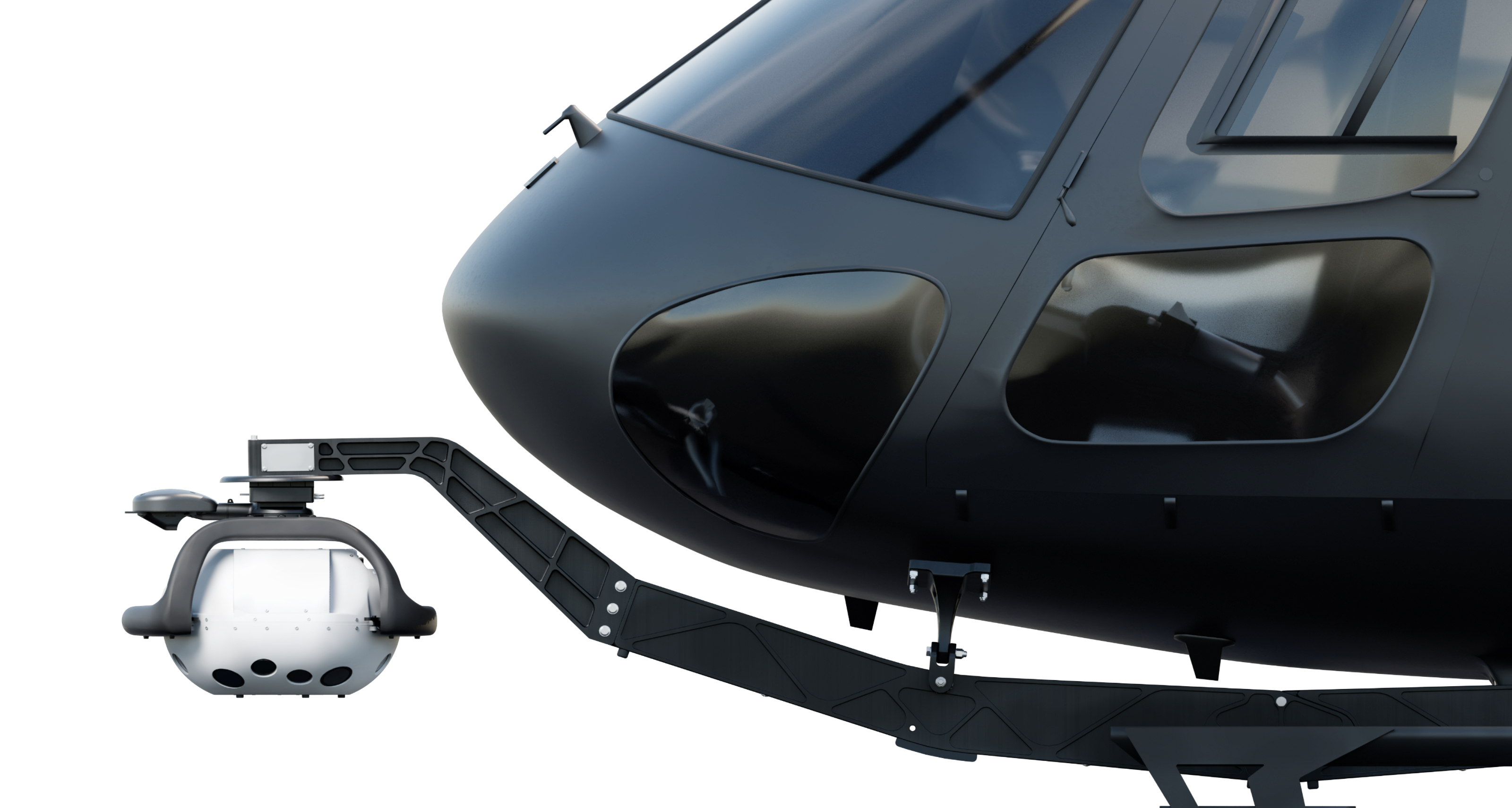
(Heerbrugg, Switzerland, 16 February 2026) Leica Geosystems, part of Hexagon, today introduced the Leica MultiMapper, a new compact hybrid airborne system combining imaging and LiDAR in one easy-to-deploy solution. Designed to fit all helicopter sizes and light fixed-wing aircraft, the system delivers efficient, high-performance data capture across multiple mapping applications.
Built for rapid mobilisation and operational flexibility
Weighing less than 25 kilogrammes, the MultiMapper is easy to handle, transport, and install. It enables pilot-only operations and reduces operational complexity. Its lightweight design supports rapid mobilisation, allowing deployment, flight, and demobilisation within a single day. This flexibility lets organisations respond quickly to diverse mission requirements, including operations in hard-to-reach areas and challenging environments.
High-performance hybrid data capture
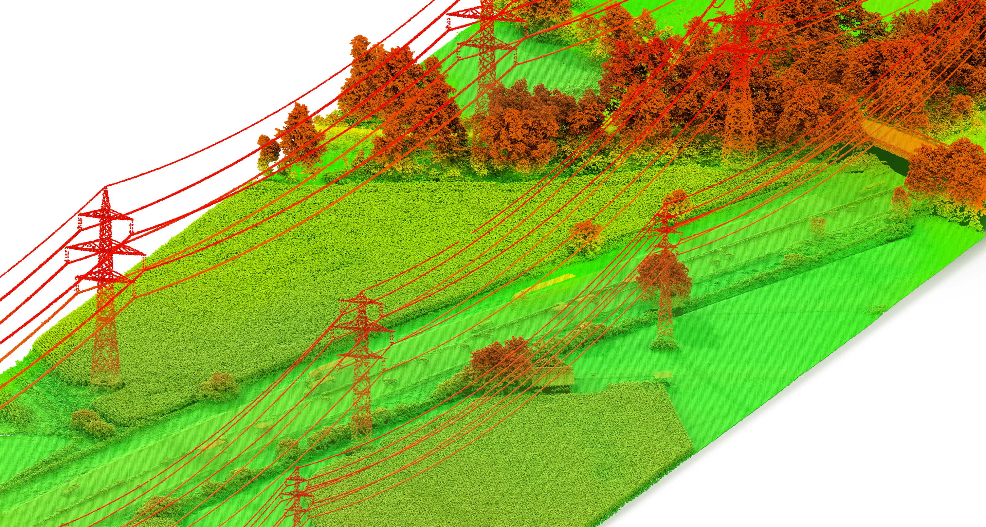
Built on Leica Geosystems’ long-standing expertise in airborne hybrid data collection, MultiMapper integrates a multi-view nadir and oblique camera with a high-density LiDAR in one single platform. This configuration enables the simultaneous collection of imagery and LiDAR data, seamlessly supporting applications ranging from city modelling and corridor mapping to infrastructure inspection, and post-event assessment.
End-to-end mapping workflows for efficient data delivery
The MultiMapper is fully supported by Leica Geosystems’ streamlined workflow suite. The new Leica AirPro FIELD app provides a tablet-based interface that allows the operator to control sensors in-flight, manage mission settings, and review flight parameters on the go, ensuring confidence in the data and efficiency throughout the mission.
“Leica MultiMapper builds on a decade of leadership in hybrid imaging and LiDAR technology, re-engineered into a compact, highly portable format,” said Werner Kirchhofer, VP of Product Development at Leica Geosystems, Scanning & Mapping Division. “More than a new system, MultiMapper marks a shift in how airborne mapping can be deployed and scaled. By enabling faster, more agile execution across diverse mission profiles, it opens the door for new users while empowering existing customers to expand their capabilities and service portfolios.”
For more information, visit: https://leica-geosystems.com/products/airborne-systems/hybrid-sensors/leica-multimapper
For further information, please contact:
Cristina Mauri, Product Marketing Manager, Airborne Sensors, Scanning & Mapping Division, Hexagon
Phone: +41 76 407 62 17
Email: cristina.mauri@hexagon.com
Leica Geosystems, quanto tem que estar certo
Com mais de 200 anos de história, a Leica Geosystems, parte da Hexagon, é a fornecedora confiável de sensores, software e serviços premium. Fornecendo valor todos os dias para profissionais em topografia, construção, infraestrutura, mineração, mapeamento e outros setores dependentes de conteúdo geoespacial, a Leica Geosystems lidera o setor com soluções inovadoras para capacitar nosso futuro autônomo.
A Hexagon (Nasdaq Stockholm: HEXA B) tem aproximadamente 24.500 funcionários em 50 países e vendas líquidas de aproximadamente 5,5 bilhões de euros.. aiba mais na hexagon.com e siga-nos em @HexagonAB.
