


Энергетическая инфраструктура
Надежные решения для максимальной эффективности

Настройте проекты мониторинга с помощью инновационных и универсальных решений
Improved safety, faster turnarounds, and easier access to accurate 3D facility documentation.

Настройте проекты мониторинга с помощью инновационных и универсальных решений
Improved safety, faster turnarounds, and easier access to accurate 3D facility documentation.

Настройте проекты мониторинга с помощью инновационных и универсальных решений
Improved safety, faster turnarounds, and easier access to accurate 3D facility documentation.

Настройте проекты мониторинга с помощью инновационных и универсальных решений
Improved safety, faster turnarounds, and easier access to accurate 3D facility documentation.

Настройте проекты мониторинга с помощью инновационных и универсальных решений
Improved safety, faster turnarounds, and easier access to accurate 3D facility documentation.
Leica Geosystems обеспечивает легкий доступ к адаптируемым решениям для мониторинга, которые соответствуют вашим требованиям.
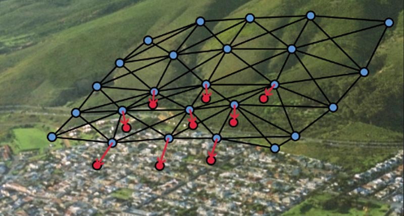
Будь то мониторинг инфраструктуры (например, плотин, трубопроводов, нефтяных платформ) с целью снижения риска, вызванного структурным напряжением в результате старения, или ущерб от стихийных бедствий, близлежащего строительства, оседания или инженерных сетей, у нас всегда есть правильное решение для вас. Обладая способностью предоставить комплексное решение от одного надежного поставщика, мы поставляем программное обеспечение, разработанное для бесперебойной работы с собственными высокопроизводительными датчиками, такими как тахеометры и ГНСС, а также с другими геотехническими датчиками и датчиками окружающей среды сторонних производителей, наряду с экспертной поддержкой и консультациями. Мониторинг с информацией в режиме реального времени и на основе автоматически созданных отчетов в соответствии с настраиваемыми графиками.

«Мы рекомендовали GeoMoS и тахеометры Leica, потому что мы использовали их во многих других проектах по всей стране с отличными результатами».
Richard Ingham (Ричард Ингам),
C.R., Государственный менеджер в Геодезическом отделе им. Кеннеди, Новый Южный Уэльс, Австралия
Примеры использования

Designing a Dam Monitoring System
East Bay Municipal Utility District (EBMUD) had the technology in place to monitor crest elevations at these dams and dikes remotely with improved temporal resolution.
East Bay Municipal Utility District (EBMUD) had the technology in place to monitor crest elevations at these dams and dikes remotely with improved temporal resolution.

Safety on the High Seas
Lukoil’s directors initiate geodynamic monitoring systems on a maritime, ice-resistant platform to ensure safe operation and to protect workers from unexpected occurrences on the high seas.
Lukoil’s directors initiate geodynamic monitoring systems on a maritime, ice-resistant platform to ensure safe operation and to protect workers from unexpected occurrences...

Slope movement monitoring at Hinkley Point C
Under construction in Somerset, England, the new Hinkley Point C (HPC) nuclear power
Under construction in Somerset, England, the new Hinkley Point C (HPC) nuclear power

Monitoring Kristanstad's Central Sewage Treatment Plant
Automated monitoring ensures full control of sensitive ground when Kristianstad’s central sewage treatment plant undergoes expansion.
Automated monitoring ensures full control of sensitive ground when Kristianstad’s central sewage treatment...
Программные продукты

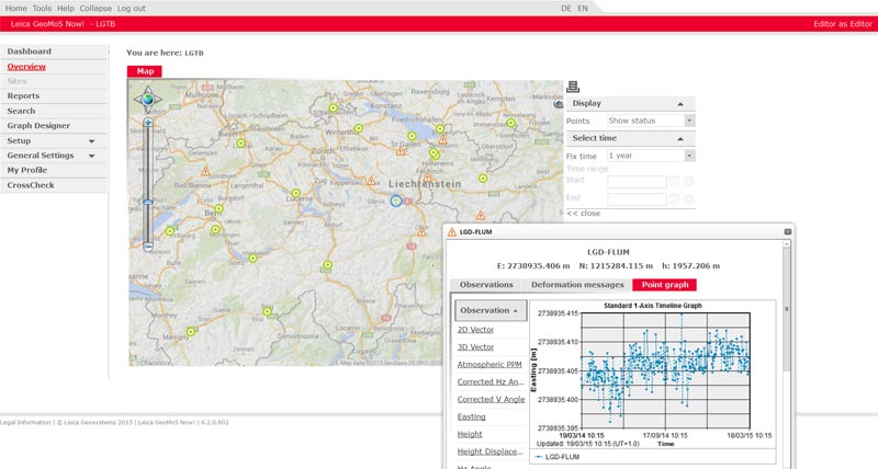
Leica GeoMoS
Flexible automatic deformation monitoring software solution.
Flexible automatic deformation monitoring software solution.

Leica GeoMoS Now!
Analyse & visualise monitoring data from everywhere.
Analyse & visualise monitoring data from everywhere.
Leica CrossCheck
A multi-purpose GNSS analysis tool for QC and monitoring.
A multi-purpose GNSS analysis tool for QC and monitoring.

Leica GNSS Spider
The core of the continuously operating reference station network
The core of the continuously operating reference station network
Leica GeoMoS Adjustment
Automatic adjustment and deformation analysis for monitoring.
Automatic adjustment and deformation analysis for monitoring.
Оборудование

Leica Nova TM50
Most accurate and reliable imaging monitoring total station.
Most accurate and reliable imaging monitoring total station.


Leica Nivel210/220 Inclination Sensor
Precision measurement of inclination vector and temperature.
Precision measurement of inclination vector and temperature.

Leica ScanStation P50
The fastest and safest, long-range 3D laser scanner.
The fastest and safest, long-range 3D laser scanner.

Leica Nova MS60
Универсальный тахеометр с возможностью сканирования и самообучения, с возможностью ГНСС подключения и цифровой визуализацией
Универсальный тахеометр с возможностью сканирования и самообучения, с возможностью ГНСС подключения и цифровой визуализацией

UAV Systems
Intelligent aerial mapping solution for surveying and construction.
Intelligent aerial mapping solution for surveying and construction.
Downloads