


Транспортная инфраструктура
Обеспечение безграничной универсальности и высокой точности
Всегда имейте под рукой данные мониторинга в режиме реального времени — они легко доступны через веб-браузер любого мобильного устройства
Improved safety, faster turnarounds, and easier access to accurate 3D facility documentation.
Всегда имейте под рукой данные мониторинга в режиме реального времени — они легко доступны через веб-браузер любого мобильного устройства
Improved safety, faster turnarounds, and easier access to accurate 3D facility documentation.
Всегда имейте под рукой данные мониторинга в режиме реального времени — они легко доступны через веб-браузер любого мобильного устройства
Improved safety, faster turnarounds, and easier access to accurate 3D facility documentation.
Всегда имейте под рукой данные мониторинга в режиме реального времени — они легко доступны через веб-браузер любого мобильного устройства
Improved safety, faster turnarounds, and easier access to accurate 3D facility documentation.
Всегда имейте под рукой данные мониторинга в режиме реального времени — они легко доступны через веб-браузер любого мобильного устройства
Improved safety, faster turnarounds, and easier access to accurate 3D facility documentation.
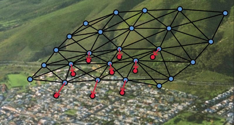
Leica Geosystems обеспечивает легкий доступ к адаптируемым решениям для мониторинга, которые соответствуют вашим требованиям.
Будь то мониторинг мостов, туннелей или геометрии железнодорожных путей на предмет воздействия строительства или нестабильности грунта, стареющая инфраструктура или увеличение срока ее службы, у нас всегда есть правильное решение для вас. Обладая способностью предоставить комплексное решение от одного надежного поставщика, мы поставляем программное обеспечение, разработанное для бесперебойной работы с собственными высокопроизводительными датчиками, такими как тахеометры и ГНСС, а также с другими геотехническими датчиками и датчиками окружающей среды сторонних производителей, наряду с экспертной поддержкой и консультациями. Мониторинг с информацией в режиме реального времени и на основе автоматически созданных отчетов в соответствии с настраиваемыми графиками.
«На нас произвело большое впечатление решение для автоматического мониторинга от Leica Geosystems. Готовый пакет не только предоставил нам тот уровень детализации и точности, который требовался от проекта, но он также не требовал работы в нерабочие часы, пока не обнаружено смещение и не активирован сигнал предупреждение. Решение дало нам полную уверенность в проекте и позволило собрать ценную информацию для анализа и отправки в Network Rail, предоставляя им доказательства того, что их инфраструктура осталась не была подвержена влиянию, а также уверенность в нашей дальнейшей работе».
Джейми Бич (Jamie Beech),
Агент BAM Nuttall
Примеры использования

Monitoring Dublin Commuters’ Safety
Construction of a group of commercial buildings were monitored to ensure the integrity of the transportation system.
Construction of a group of commercial buildings were monitored to ensure the integrity of the transportation system.

Underneath King’s Cross Redevelopment
King’s Cross is one of the most significant reconstruction projects in London, UK.
King’s Cross is one of the most significant reconstruction projects in London, UK.

Innovative System Ensures Vertical Alignment of Gerald Desmond Bridge
The Gerald Desmond Bridge is being replaced and will be California’s first long span, cable-stayed bridge, with an additional 50 feet of clearance, making it one of the tallest cable-stayed bridges in the United States.
The Gerald Desmond Bridge is being replaced and will be California’s first long span, cable-stayed bridge, with an additional 50 feet of clearance, making it one of the...

Ensuring Smooth Flow
Germany’s busy Kiel Canal has been used as an international shipping lane for more than 100 years.
Germany’s busy Kiel Canal has been used as an international shipping lane for more than 100 years.
Программные продукты

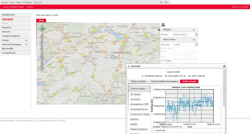
Leica GeoMoS
Flexible automatic deformation monitoring software solution.
Flexible automatic deformation monitoring software solution.

Leica GeoMoS Now!
Analyse & visualise monitoring data from everywhere.
Analyse & visualise monitoring data from everywhere.
Leica CrossCheck
A multi-purpose GNSS analysis tool for QC and monitoring.
A multi-purpose GNSS analysis tool for QC and monitoring.

Leica GNSS Spider
The core of the continuously operating reference station network
The core of the continuously operating reference station network
Leica GeoMoS Adjustment
Automatic adjustment and deformation analysis for monitoring.
Automatic adjustment and deformation analysis for monitoring.
Оборудование

Leica Nova TM50
Most accurate and reliable imaging monitoring total station.
Most accurate and reliable imaging monitoring total station.


Leica Nivel210/220 Inclination Sensor
Precision measurement of inclination vector and temperature.
Precision measurement of inclination vector and temperature.

Leica ScanStation P50
The fastest and safest, long-range 3D laser scanner.
The fastest and safest, long-range 3D laser scanner.

Leica Nova MS60
Универсальный тахеометр с возможностью сканирования и самообучения, с возможностью ГНСС подключения и цифровой визуализацией
Универсальный тахеометр с возможностью сканирования и самообучения, с возможностью ГНСС подключения и цифровой визуализацией

UAV Systems
Intelligent aerial mapping solution for surveying and construction.
Intelligent aerial mapping solution for surveying and construction.
Downloads