


Leica Cyclone MODEL VR
Expérience immersive en réalité virtuelle de vos modèles Cyclone

Entrez dans le futur de la visualisation avec Cyclone MODEL VR. Ce dernier-né de la famille de produits Leica Geosystems HDS (Leica Geosystems High-Definition Surveying) permet aux utilisateurs de publier des modèles Cyclone en tant qu'environnements de réalité virtuelle immersifs (VR) ou de visites de site virtuelles, de conception-visualisation et de collaboration.
Vitesse de visualisation
Ne limitez plus vos données 3D à un écran 2D. Maintenant, pour la toute première fois, vous pouvez publier vos modèles Cyclone directement en VR pour vivre vos données dans leur vrai format 3D. Avec la suite complète de la technologie de Leica Geosystems, les utilisateurs peuvent désormais simuler des environnements dangereux ou potentiellement dangereux pour évaluer des plans de conception ou des activités et limiter leur temps de présence sur le terrain.
Collaboration plus intelligente
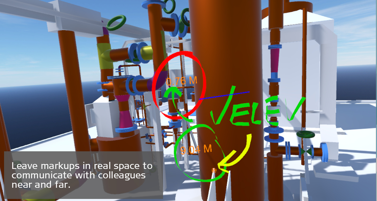
La communication efficace est essentielle au maintien d’un projet dans les délais et pour garder les clients engagés et satisfaits. Cyclone MODEL VR vous permet non seulement d’annoter votre environnement en temps réel, mais également d’enregistrer des captures de vos changements proposés pour que les autres les mettent en oeuvre, en éliminant ainsi la confusion et en permettant une collaboration plus intelligente. Vous pouvez même partager vos expériences en VR avec des collègues ou clients à distance, pour leur permettre de vivre l’expérience eux-mêmes.
Intégration plus intelligente
Lorsque vous ne pouvez pas vous rendre sur un site, une modélisation 3D est la meilleure alternative, mais maintenant avec Cyclone MODEL VR, vous pourrez vous immerger dans vos modèles comme jamais auparavant. Grâce à une navigation intuitive et à un ensemble robuste d’annotations, de mesures et d’outils de communication, vous pouvez vraiment accéder à la pratique de votre travail. Soit vous vous téléportez à des emplacements en utilisant vos contrôleurs soit vous marchez dans votre environnement. L’échelle 1:1 rend cet outil parfait pour la planification et la revue de conception ou obtenir l’adhésion du client sur un nouveau projet.
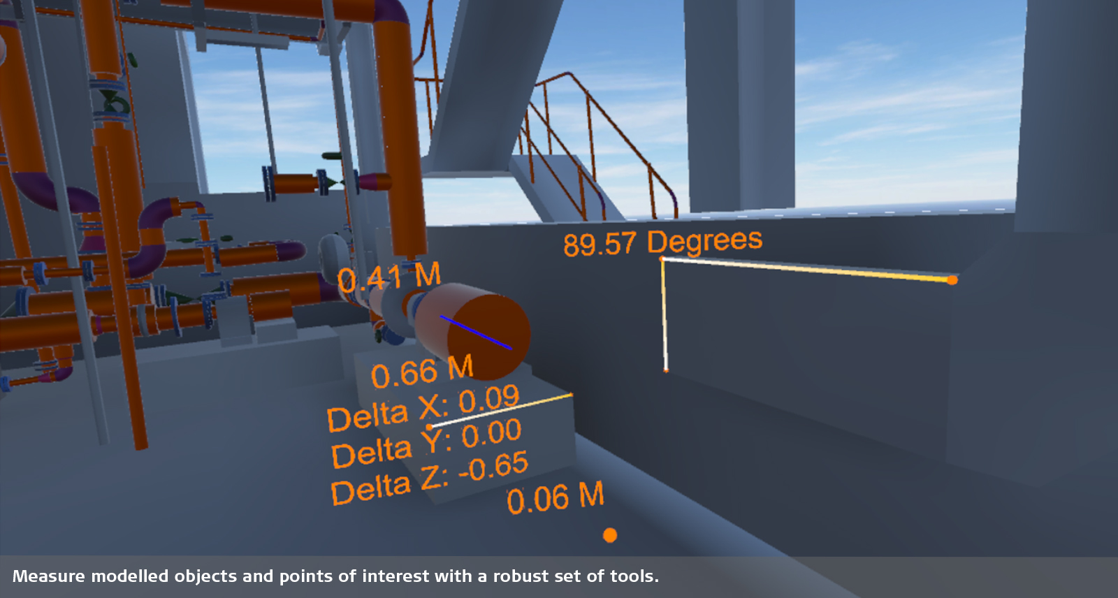
Boite à outils robuste
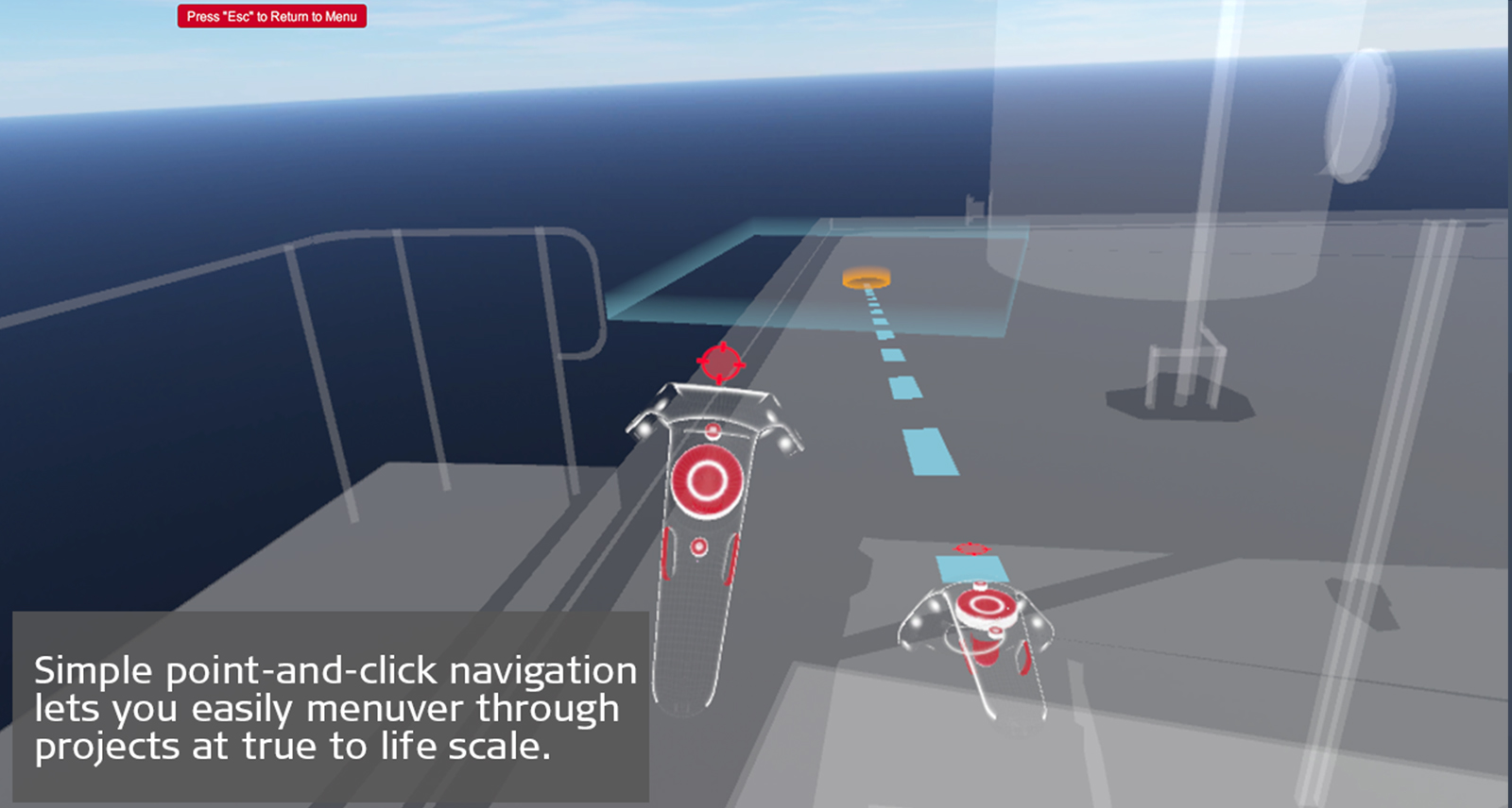
Cyclone MODEL VR comprend des outils de mesure et d’annotations interactifs pour attirer l’attention sur des points d’intérêts. Une navigation simple, du type pointer et cliquer vous permet de manœuvrer facilement dans vos modèles. Naviguez entre les étages ou prenez une vue à vol d’oiseau de la scène afin d’acquérir davantage de contexte.
Cyclone MODEL VR est un logiciel de visualisation gratuit. Les utilisateurs doivent publier leurs modèles à partir de Cyclone MODEL VR avec une licence Cyclone MODEL VR PUBLISHER.
Fiches techniques
Leica Cyclone MODEL VR fiche technique
Leica Cyclone PUBLISHER fiche technique
Spécifications techniques
Leica Cyclone spécification technique
Leica Cyclone PUBLISHER spécification technique
Surveying & Engineering
Exact scan of two cooling towers
Scan Till You Drop
Exploring The Rate Of Climate Change From Deep Within The Earth
Game On With Laser Scanning
Fitting Together Pieces Of A Puzzle
When Every Millimetre Counts
Creating A New Ski Jump Complex
How Hollis Captures Processes Manages And Delivers Reality Capture Data
Surveying Germany's Biggest Aqua Park
Capturing Reality in One of the World's Busiest Airports
Laser Scanning has Transformed Efficiency for Faithful Registered Surveying in Japan
Building Construction / AEC
Reality Capture For BIM
From Paper Maps To Laser Scans
Speeding Up BIM Reconstruction of Historical Building with Laser Scanning
From Tape To Point Cloud
Using Laser Scanning Technology for Retail Redevelopment
Bringing BIM4ALL
Gilbert Ash Constructs Mayhew Theatre at the UK Foreign & Commonwealth Office
Infrastructure
Advancing Mexico's Transportation Infrastructure
Improving the Railway Infrastructure of a Capital City
Scans, Spans and Automobiles
Mirroring Reality for Rail
Setting the World’s Shortest Railway Back on Track
Protecting Heritage with Upgraded Rail Clearance
Plants & Ships
Plain Sailing with 3D Plant Design
SOS Shipbuilding on Scans
Sweet Success in Plant Documentation
Bringing Safety Productivity with Laser Scanning
Leica Geosystems Laser Scanners and Hexagon PPM 3D Design Software Access 'True Reality'
Revolutionising the Luxury Yacht Building Industry with Laser Scanning
How Element6 Delivers the Future of Plant Engineering with Laser Scanning
Renovating Complex Structures with 3D Laser Scanning
Fighting Time and Tide to Capture a 5 Hectare Coastal Construction Site in 3D
Recipe for Success: 3D Laser Scanning for Tank Inspections
Public Safety
How Johnsons County is Recreating Crime Scenes with Laser Scanning
Changing the Game for Public Safety Professionals with the World's Fastest Laser Scanner
Transforming Reality into Photorealistic Virtual Reality with Laser Scanning
Heritage
The Reality Capture Of Ellis Island
Digitising The Mighty Taj Mahal
Predicting The Future By Analysing The Past
The Lower The Safer
Preserving Mankind's Past from Mother Natures Quakes
Transforming Ayacucho into a Digital City
Digitalising Frank Lloyd Wrights Desert Laboratory
Digitalising The Spanish Royal Palace with Laser Scanning
Digitally Preserving Hukuru Miskiy
Capturing Egypt's Sistine Chapel with the BLK360
Unveiling the Mystery - An Ancient Water Clock with Laser Scanning
Preserving Romania's Speleological Heritage with Point Cloud and GNSS Data
Rescue Mission: Using Reality Capture to Plan the Redevelopment of a Former Convent
Utilities
From the Laser Scanner to the Office in Near Real Time
Science & Education
Protecting The Alpine Rhine Valley From Flooding
Media & Entertainment
Blockbuster scanning: Using LiDAR for Joker & John Wick
Laser Scanners
Leica BLK360
Leica RTC360
Leica ScanStation P40 / P30
Leica ScanStation P50
Software
Leica CloudWorx
Leica TruView
Leica JetStream
Leica Map360
Accessories
3D Laser Scanner Accessories

Contact Solutions 3D
Prenez contact avec nos experts pour plus d'information sur nos solutions 3D.
Prenez contact avec nos experts pour plus d'information sur nos solutions 3D.

The High-Definition Surveyor - Blog
Learn how Leica Geosystems laser scanning solutions are helping professional to shape the future of our world.
Learn how Leica Geosystems laser scanning solutions are helping professional to shape the future of our world.


A smarter way to view the world
In a world of fast changing technologies and visualisation there has never been a better way to interact, measure and share environments than with Leica Cyclone, a smarter way to view the world.