


Leica Cyclone MODEL VR
Immersive virtual reality viewing of your Cyclone models

Step into the future of visualisation with Leica Cyclone MODEL VR. This latest addition to the Leica Geosystems High-Definition Surveying (HDS) viewing product family allows users to publish Cyclone models as immersive virtual reality (VR) environments perfect or virtual site visits, design-visualisation and collaboration.
Rapid design visualisation
No longer confine your 3D data to the 2D screen. Now, for the first time ever, you can publish your Cyclone models directly to VR to experience your data in its native 3D format. With the full suite of Leica Geosystems’ technology, users can now simulate dangerous or potentially harmful environments to evaluate design plans or activities and limit their time in the field.
Smarter collaboration
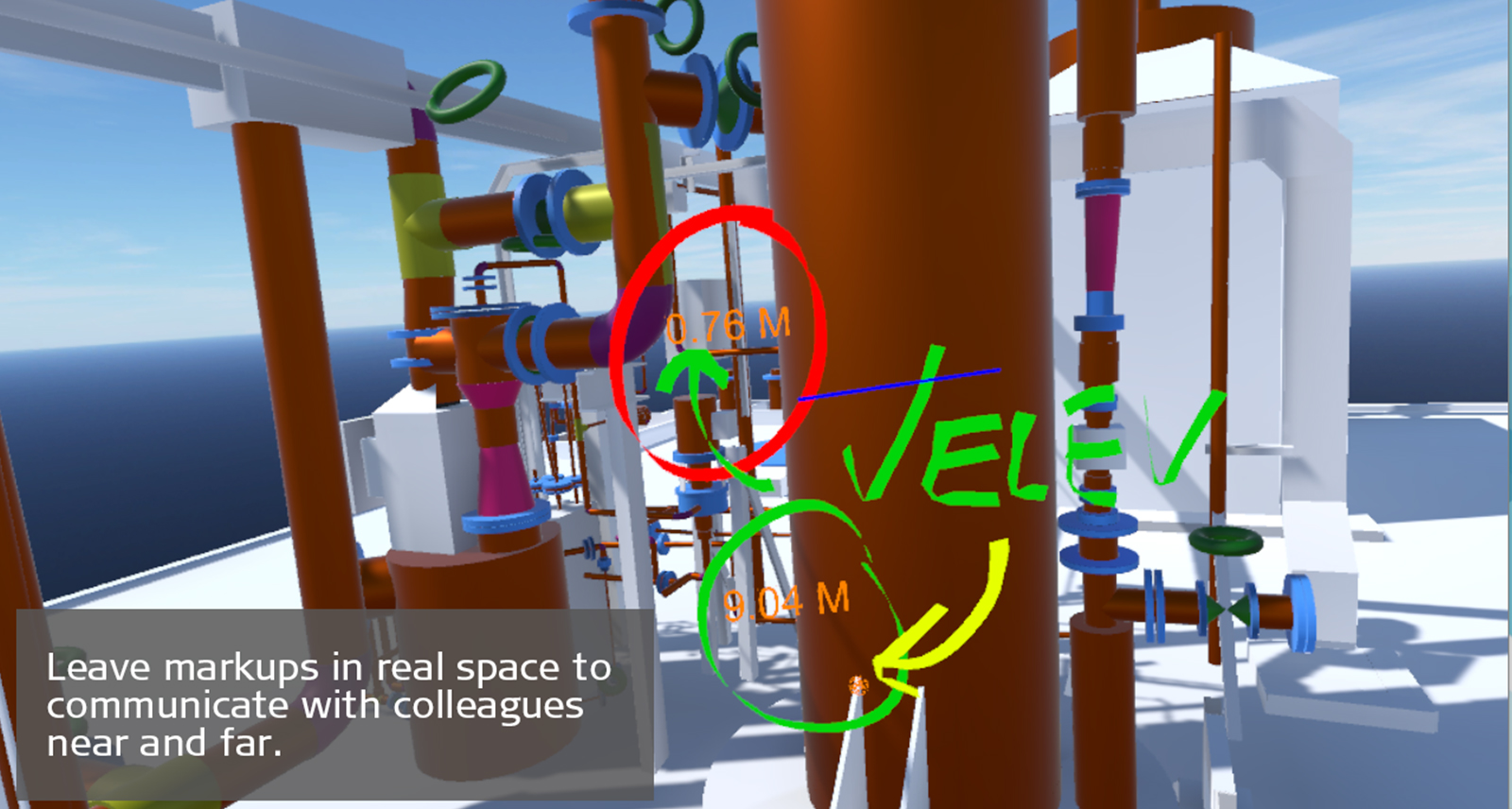
Communicating your ideas and designs effectively is key to keeping a project on schedule and keeping clients engaged and happy. Cyclone MODEL VR allows you not only mark up your environment in real time but save snapshots of your proposed changes for others to implement, eliminating confusion and enabling smarter collaboration. Even share your VR experiences with colleagues or clients remotely to let them experience it for themselves.
Smarter interaction
When you can’t get to a site, a model is the next best thing, but now with Cyclone MODEL VR, you can immerse yourself in your models like never before. With intuitive navigation and a robust set of mark up, measurement and communication tools, you can get truly hands-on with your work. Either remotely access locations using your controllers or walk around your environment. The 1:1 scale makes it the perfect tool for planning and design review or to get client buy-in on a new project.
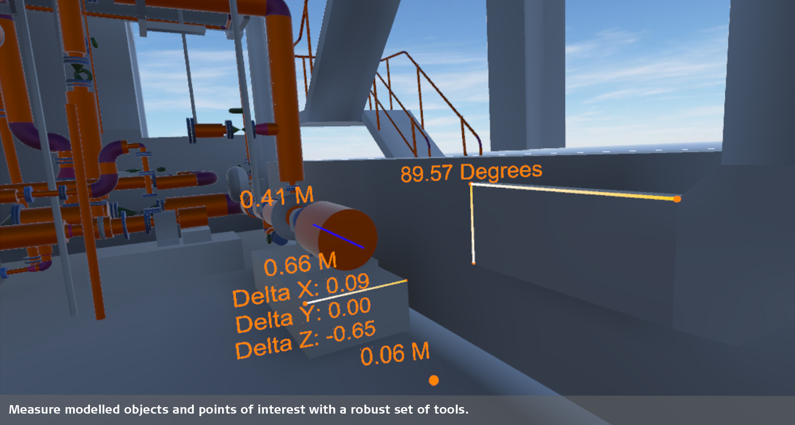
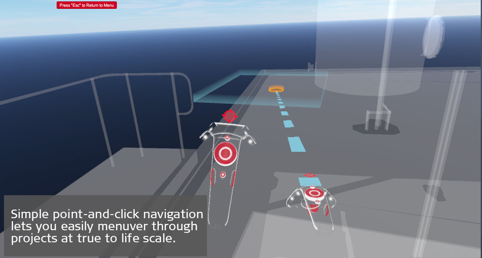
Robust toolset
Cyclone MODEL VR includes measurement and markup tools perfect for intuitive visualisation and collaboration. Simple, point-and-click navigation lets you easily maneuver through your models. Navigate between floors or take a bird’s eye view of the scene to gain greater context.
Cyclone MODEL VR is a free viewing software. Users must publish their models from Cyclone MODEL VR with a Cyclone MODEL VR PUBLISHER licence.
Data Sheets
Leica Cyclone MODEL VR
Leica Cyclone PUBLISHER
Technical Specifications
Leica Cyclone
Leica Cyclone PUBLISHER
Surveying & Engineering
Exact scan of two cooling towers
Scan till you drop
Exploring the rate of climate change from deep in the Earth
Game on with laser scanning
Fitting together pieces of a puzzle
When every millimetre counts
Creating a new ski jump complex
How Hollis captures, processes, manages and delivers reality capture data
Building Construction / AEC
Reality capture for BIM
From paper maps to laser scans
Speeding up BIM-reconstruction
From tape to point cloud
Using laser scanning technology for retail redevelopment
Infrastructure
Off the boat, into the air
Advancing Mexico's transportation infrastructure
Improving the railway infrastructure of a capital city
Scan, spans and automobiles
Mirroring reality for rail
Setting the world's shortest railway back on track
Protecting heritage with upgraded rail clearance
Plants & Ships
Plain sailing with 3D plant design
SOS shipbuilding on scans
Sweet success in plant documentation
Bringing safety, productivity with laser scanning
Leica Geosystems laser scanners and Hexagon PPM 3D design software access 'true reality'
Revolutionising the luxury yacht building industry with laser scanning
Renovating complex structures with 3D laser scanning
Public Safety
How Johnson's County is recreating crime scenes with laser scanning
Changing the game for public safety professionals with the world's fastest laser scanner
How Element6 delivers the future of Plant Engineering with laser scanning
Transforming reality into photorealistic Virtual Reality with laser scanning
Heritage
The reality capture of Ellis Island
Digitising the mighty Taj Mahal
Predicting the future by analysing the past
The lower, the safer
Preserving mankind's past from mother nature's quake
Transforming Avacuhco into a digital city
Digitising Frank Lloyd Wright's desert laboratory
Digitalising the Spanish Royal Palace with laser scanning
Transforming ruins to 3D models
Preserving digitally Hukuru Miskiy
Capturing Egypt’s Sistine Chapel with the BLK360
Unveiling the mystery - an ancient water clock with laser scanning
Preserving Romania's speleological heritage with point cloud and GNSS data
Utilities
From the laser scanner to the office in near real time

Pyydä meiltä lisätietoa laserkeilauksesta
Pyydä meiltä lisätietoa laserkeilaustuotteistamme.
Pyydä meiltä lisätietoa laserkeilaustuotteistamme.