


Leica Cyclone MODEL VR
Meeslepende virtual reality-weergave van uw Cyclone-modellen

Stap in de toekomst van visualisatie met Leica Cyclone MODEL VR. Met deze nieuwste aanwinst in de weergaveproductfamilie van Leica Geosystems High-Definition Surveying (HDS) kunnen gebruikers Cyclone-modellen publiceren als meeslepende virtual reality (VR)-omgevingen die perfect zijn voor virtuele bezoeken aan de locatie, ontwerpvisualisatie en samenwerking.
Snelle visualisatie van het ontwerp
Beperk uw 3D-gegevens niet langer tot het 2D-scherm. U kunt nu, voor het eerst, uw Cyclone-modellen direct naar VR publiceren om uw gegevens in het oorspronkelijke 3D-formaat te ervaren. Met de volledige suite technologie van Leica Geosystems kunnen gebruikers nu gevaarlijke of potentieel schadelijke omgevingen simuleren om ontwerpplannen of activiteiten te evalueren en hun tijd in het veld te beperken.
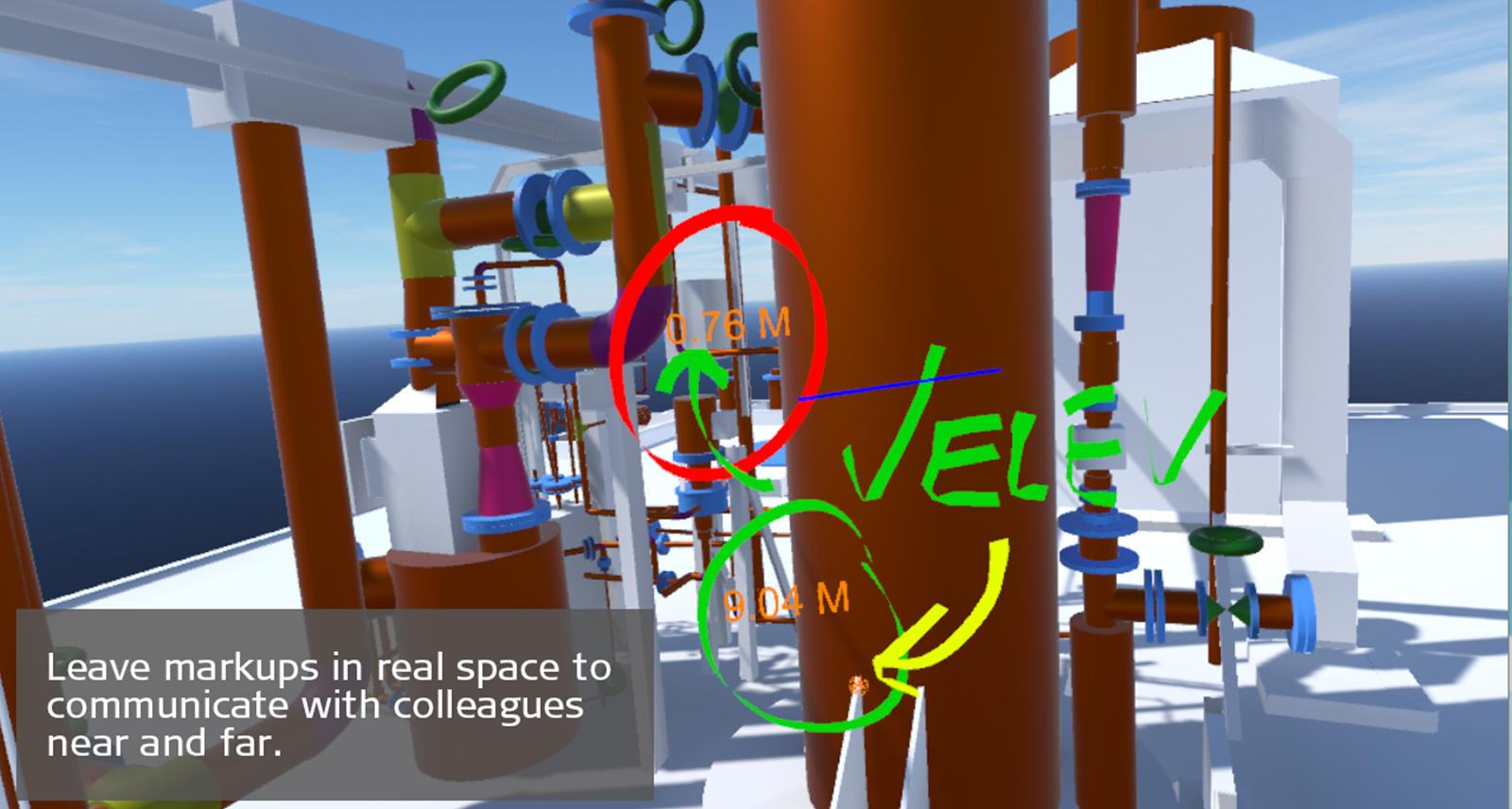
Slimmere samenwerking
Uw ideeën en ontwerpen effectief communiceren is belangrijk om een project op schema te houden en klanten betrokken en tevreden te houden. Met Cyclone MODEL VR kunt u niet alleen uw omgeving in realtime markeren, maar ook momentopnames van uw voorgestelde wijzigingen opslaan zodat anderen die kunnen implementeren, wat verwarring voorkomt en een slimmere samenwerking mogelijk maakt. Deel zelfs uw VR-ervaringen met collega's of klanten op afstand, zodat zij die zelf ervaren.
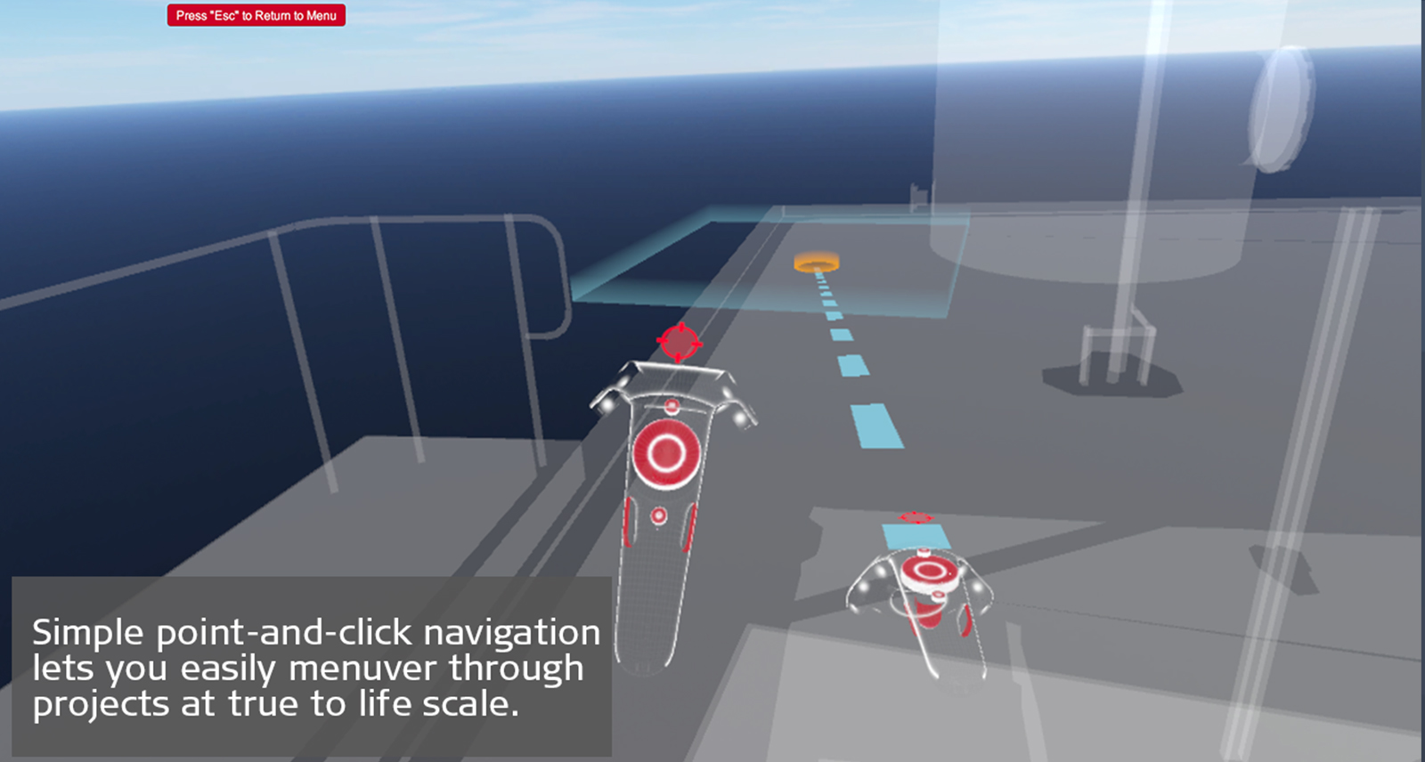
Slimmere interactie
Wanneer u een bouwplaats niet kunt bereiken, is een model een prima alternatief, maar met Cyclone MODEL VR kunt u zichzelf nu onderdompelen in uw modellen als nooit tevoren. Met intuïtieve navigatie en een robuuste reeks markeer-, meet- en communciatiehulpmiddelen kunt u echt aan de slag met uw werk. Krijg toegang tot locaties op afstand met behulp van uw controllers of loop om uw omgeving heen. De 1:1 schaal maakt dit het perfecte hulpmiddel om te plannen en ontwerpen te bekijken of om klanten een nieuw project te laten inkopen.
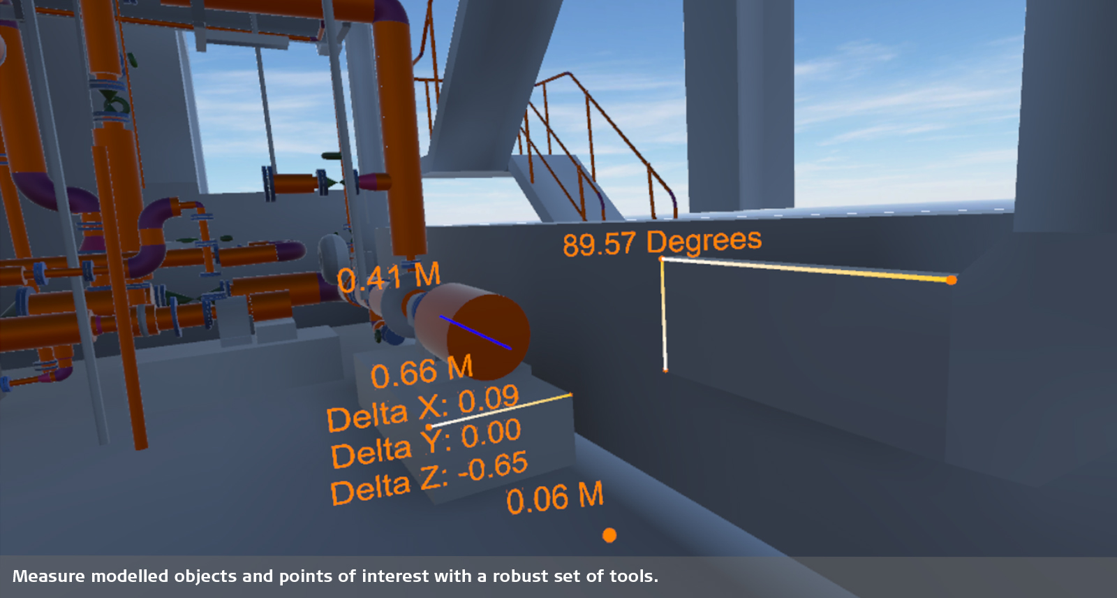
Robuuste toolset
Cyclone MODEL VR omvat meet- en markeerhulpmiddelen die perfect zijn voor intuïtieve visualisatie en samenwerking. Eenvoudige navigatie via aanwijzen en aanklikken laten u gemakkelijk manoeuvreren door uw modellen. Navigeer tussen verdiepingen of bekijk de plaats in vogelvlucht om meer context te krijgen.
Cyclone MODEL VR is gratis virtual reality visualisatiesoftware. Gebruikers moeten hun modellen van Cyclone MODEL VR met een Cyclone MODEL VR PUBLISHER-licentie publiceren.
Surveying & Engineering
Exact scan of two cooling towers
Scan Till You Drop
Exploring The Rate Of Climate Change From Deep Within The Earth
Game On With Laser Scanning
Fitting Together Pieces Of A Puzzle
When Every Millimetre Counts
Creating A New Ski Jump Complex
How Hollis Captures Processes Manages And Delivers Reality Capture Data
Surveying Germany's Biggest Aqua Park
Capturing Reality in One of the World's Busiest Airports
Laser Scanning has Transformed Efficiency for Faithful Registered Surveying in Japan
Building Construction / AEC
Reality Capture For BIM
From Paper Maps To Laser Scans
Speeding Up BIM Reconstruction of Historical Building with Laser Scanning
From Tape To Point Cloud
Using Laser Scanning Technology for Retail Redevelopment
Bringing BIM4ALL
Gilbert Ash Constructs Mayhew Theatre at the UK Foreign & Commonwealth Office
Infrastructure
Advancing Mexico's Transportation Infrastructure
Improving the Railway Infrastructure of a Capital City
Scans, Spans and Automobiles
Mirroring Reality for Rail
Setting the World’s Shortest Railway Back on Track
Protecting Heritage with Upgraded Rail Clearance
Plants & Ships
Plain Sailing with 3D Plant Design
SOS Shipbuilding on Scans
Sweet Success in Plant Documentation
Bringing Safety Productivity with Laser Scanning
Leica Geosystems Laser Scanners and Hexagon PPM 3D Design Software Access 'True Reality'
Revolutionising the Luxury Yacht Building Industry with Laser Scanning
How Element6 Delivers the Future of Plant Engineering with Laser Scanning
Renovating Complex Structures with 3D Laser Scanning
Fighting Time and Tide to Capture a 5 Hectare Coastal Construction Site in 3D
Recipe for Success: 3D Laser Scanning for Tank Inspections
Public Safety
How Johnsons County is Recreating Crime Scenes with Laser Scanning
Changing the Game for Public Safety Professionals with the World's Fastest Laser Scanner
Transforming Reality into Photorealistic Virtual Reality with Laser Scanning
Heritage
The Reality Capture Of Ellis Island
Digitising The Mighty Taj Mahal
Predicting The Future By Analysing The Past
The Lower The Safer
Preserving Mankind's Past from Mother Natures Quakes
Transforming Ayacucho into a Digital City
Digitalising Frank Lloyd Wrights Desert Laboratory
Digitalising The Spanish Royal Palace with Laser Scanning
Digitally Preserving Hukuru Miskiy
Capturing Egypt's Sistine Chapel with the BLK360
Unveiling the Mystery - An Ancient Water Clock with Laser Scanning
Preserving Romania's Speleological Heritage with Point Cloud and GNSS Data
Rescue Mission: Using Reality Capture to Plan the Redevelopment of a Former Convent
Utilities
From the Laser Scanner to the Office in Near Real Time
Science & Education
Protecting The Alpine Rhine Valley From Flooding
Media & Entertainment
Blockbuster scanning: Using LiDAR for Joker & John Wick

Contact us about Laser Scanning
Get in contact with us for more information about our laser scanning portfolio.
Get in contact with us for more information about our laser scanning portfolio.

The High-Definition Surveyor - Blog
Ontdek hoe de laserscanoplossingen van Leica Geosystems professionals helpen om de toekomst van onze wereld vorm te geven.
Ontdek hoe de laserscanoplossingen van Leica Geosystems professionals helpen om de toekomst van onze wereld vorm te geven.


A smarter way to view the world
In a world of fast changing technologies and visualisation there has never been a better way to interact, measure and share environments than with Leica Cyclone, a smarter way to view the world.