


Dostępne wkrótce: Pierwsze niwelatory laserowe z rozszerzalną funkcjonalnością
Nowy niwelator laserowy jest już w drodze

Czy Twój niwelator laserowy jest gotowy na rozszerzenie funkcjonalności? Przygotuj się na spotkanie z niwelatorem laserowym, który dostosowuje się do otoczenia.
Jeśli chcesz dowiedzieć się więcej o pierwszych niwelatorach laserowych, których funkcjonalność można rozszerzyć, wypełnij poniższy formularz i uzyskasz informacje od jednego z naszych przedstawicieli.
Connected and simplified workflow
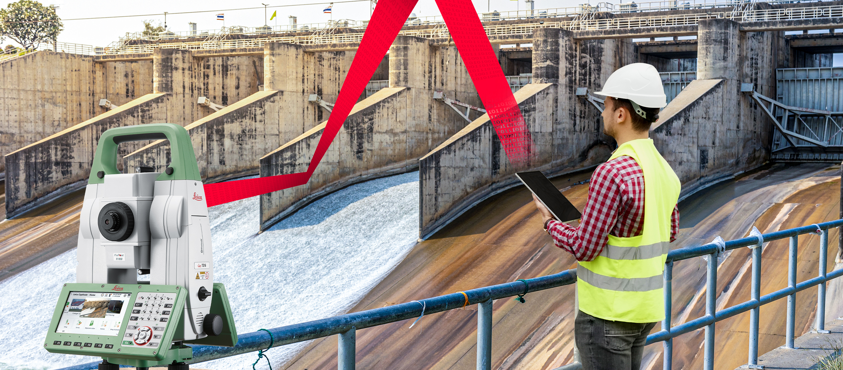
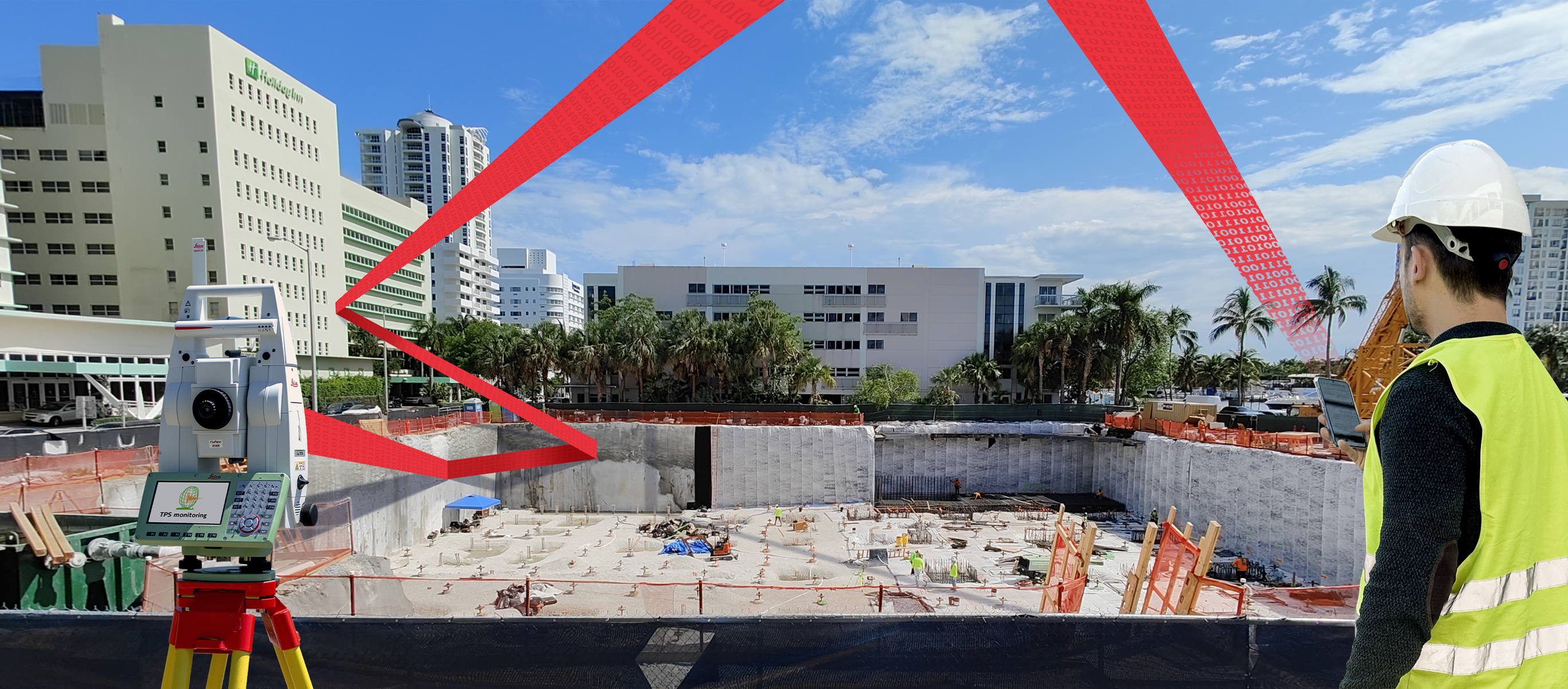
Optimise your semi-automated monitoring workflow with the seamlessly connected Captivate TPS Monitoring app and GeoMoS Now! Survey Edition. Total station measurements, calculations, and instant notifications are completed with the Captivate TPS Monitoring app before data is automatically imported into GeoMoS Now! Survey Edition. Here you benefit from real-time visualisations on your personalised dashboard and automated, fully customisable reporting – all accessible wherever you are from your tablet or smartphone over a browser.
Real-time visualisation
Real-time measurement visualisations ensure you are up to date with the deformation data you need, wherever you are. GeoMoS Now! Survey Edition provides visualisations of calculated displacements on your customised dashboard as soon as data is imported from Captivate – so you immediately see and share the most relevant information. Visualise displacements on a map, select from a variety of chart types and raster or vector backgrounds, and create tables for automatically updated value tracking. Access your data securely in the field or any other location over any smart device without travelling back to the office for data processing, saving time and enhancing efficiency.
Personalised dashboards
With a range of visualisation customizations for calculated results, your personalized dashboard provides easy access to an overview of essential and up-to-date displacement data for your project. Customize what you see by selecting charts and graphs with different metrics, adding dataset layers, set thresholds values for different limit levels, and visualize critical deformation levels. With 16 templates, including timeline and vector graphs, scatter plots, bar charts, contour graphs, and more, you can see all the information you need in the visual package best suited to your project. Additionally, charts and maps are automatically updated each time new data is imported so that your custom dashboards are always current.
Customised and automated reporting
Save even more time with fully automated, customizable reports. GeoMoS Now! Survey Edition allows you to provide results with professionalism by creating reports from fully tailorable templates featuring your company branding. Automate these reports to be generated and sent at defined intervals to a designated list of recipients and be confident that your results are getting to the right stakeholders, at the right time.
| Laser Tools ul. Podmiejska 17A 66-400 Gorzów Wielkopolski T: +48 606 671 777 E: piotr@laser.tools |
Kup teraz | |
| Makrogeo Weronika Dylus - Skudlik ul. Mickiewicza 23 41-700 Ruda Śląska T: +48 32 725 02 42 E: makrogeo@makrogeo.pl |
Kup teraz | |
| mierzymy.pl Marek Pudło ul. Polna 206A 05-311 Dębe Wielkie T: +48 504 155 467 E: sklep@mierzymy.pl |
Kup teraz | |
| Profi Partner Sp. z o. o. ul. Posag 7 Panien 6 02-495 Warszawa T: +48 693 532 088 E: piotr.juszczyk@profipartner.pl |
Kup teraz | |
| Prossper Paweł Chrzanowski ul. Strzelecka 12 64-800 Chodzież T: +48 61 641 77 75 E: pawel.c@prossper.pl |
Kup teraz | |
| Reper Adam Jamróżkiewicz ul. Tęczowa 43A 55-106 Zawonia T: +48 881 464 788 E: adam.leica@gmail.com |
Kup teraz | |

Oryginalne Akcesoria
Korzystaj z jakości, precyzji i niezawodności oryginalnych akcesoriów Leica Geosystems.