


Leica Pegasus:Backpack Wearable Mobile Mapping Solution
Versatile and wearable platform for indoor & outdoor reality capture

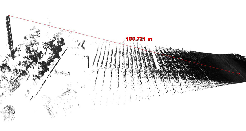
In today’s complex world, keeping pace with the speed of change is a challenge for all professionals in any industry. The Leica Pegasus:Backpack is the award-winning wearable reality capture solution enabling you to make quick and informed decisions in fast-changing, challenging and hostile environments. This GNSS agnostic solution captures immersive 360° imagery, and the optional 200m long range scanner improves data completeness for tall constructions such buildings, increases the flexibility and efficiency of your investment. Just by walking, this multidisciplinary system allows you to digitise pedestrianised city centres, the progress of construction sites, building interiors, underground structures and many more challenging applications.

The Leica Pegasus:Backpack is the award-winning wearable reality capture solution enabling you to make quick and informed decisions in fast-changing, challenging and hostile environments.

The Pegasus:Backpack innovative characteristics of the system result in a wearable reality capture solution to obtain professional documentation and enables to keep pace with constant changes in our todays growing societies.
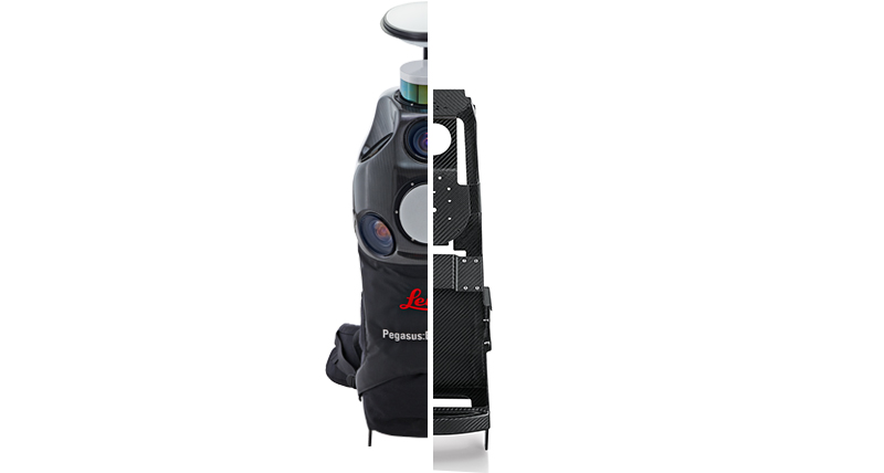
Starting from the futuristic product design to the use of carbon fibre to reduce weight and increase the ergonomic. Continuing with the embedded technology, dual LiDAR, five high dynamic cameras, IMU and SLAM navigation technology, it is a unique data collection tool for the modern surveyor.
The combination of these distinguished characteristics makes the Pegasus:Backpack extremely versatile for outdoor and indoor applications enabling customers to spend less time on the field, differentiate their business model, and stay competitive in a consolidating market.
The core technology centres on navigation. The Pegasus:Backpack distinguish indoor and outdoor missions and applied two positioning methods. The two positioning methods are Fused SLAM and Pure SLAM
The Fused SLAM method is a pure outdoor or a combined outdoor with indoor mission. In a pure outdoor environment, the system uses its integrated GNSS antenna for positioning while the IMU records the attitude. The two are combined into precise localization of the data to maximizing the trajectory precision. In combined indoor / outdoor missions, simultaneous location and mapping (SLAM) algorithms are used to get accurate positional information in GNSS denied areas. SLAM is using the scanner data to constantly calculate the system position and increase the positional accuracy.
The Pure SLAM method acquires for indoor only missions. In complete absence of GNSS a first trajectory estimation is calculated from IMU observations. In a second step SLAM is applied to refine the initial IMU-based generated point cloud to the point cloud from the SLAM scanner.

Digital Twin
Flexible operation: may be used while walking, may also be used while riding a bicycle, electric vehicle, balance vehicle, etc.; may be operated indoors and outdoors, collect complete data without blind spots.
Rich detail and information: simultaneously collect on-site photos and 3D point clouds, suited for automatic information extraction, no need to return to the actual site to take additional measurements after the data collection.
Topographic survey
Data completeness: No need to return to the site in case some details are missed. Cameras and scanners provide a complete replica of the environment.
Fast office processing. The drawing process is completed with standard CAD tools.
Underground survey
Mobile mapping works under challenging light conditions: with the Pegasus:Backpack you can capture well exposed photos with the additional flash light module.
Collect complete indoor structures, signs and markings while walking. Data completeness is ensured. No need to return to the actual site due to missed objects.
Cadastral survey
Efficient field measurements: data can be acquired while riding a bike or electric vehicle. (4-5 times more efficient than traditional methods)
Agile data collection: with Pegasus:Backpack you can sneak into narrow alleys, corridors, and fields, which are difficult to reach using traditional methods or drones.


Wearable reality-capture technology

Skontaktuj się z nami w sprawie rozwiązań mobilnego mapowania
Skontaktuj się z nami, aby uzyskać więcej informacji na temat naszych rozwiązań w zakresie mobilnego mapowania.
Skontaktuj się z nami, aby uzyskać więcej informacji na temat naszych rozwiązań w zakresie mobilnego mapowania.

Reality Capture Newsletter
Kliknij tutaj, aby zapisać się do naszego regularnego biuletynu i być na bieżąco z najnowszymi wiadomościami dotyczącymi przechwytywania rzeczywistości.
Kliknij tutaj, aby zapisać się do naszego regularnego biuletynu i być na bieżąco z najnowszymi wiadomościami dotyczącymi przechwytywania rzeczywistości.

Historie i Spostrzeżenia
Odkryj, jak technologia mobilnego mapowania umożliwia naszym klientom regularne rejestrowanie i digitalizację w 3D zmieniającego się otoczenia.
Odkryj, jak technologia mobilnego mapowania umożliwia naszym klientom regularne rejestrowanie i digitalizację w 3D zmieniającego się otoczenia.

HxGN SmartNet
HxGN SmartNet dostarcza zaufane dane GNSS z ponad 5 300 stacji referencyjnych na całym świecie.
HxGN SmartNet dostarcza zaufane dane GNSS z ponad 5 300 stacji referencyjnych na całym świecie.

Skontaktuj się z naszymi Ekspertami ds. Bezpieczeństwa Publicznego, Ochrony i Kryminalistyki
Doradztwo od doświadczonych ekspertów ds. bezpieczeństwa publicznego
Doradztwo od doświadczonych ekspertów ds. bezpieczeństwa publicznego